
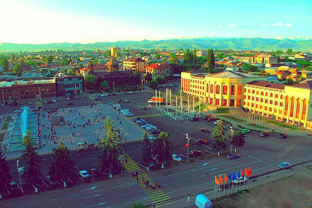
Gyumri
Gyumri (Armenian: Գյումրի) is the second-largest city in Armenia and the administrative capital of Shirak Province. It sits in the middle of the Shirak Plain at 1,550 metres above sea level, 126 km northwest of Yerevan. Around 120,000 people live here. Gyumri is officially recognised as the cultural capital of Armenia and is one of the very few cities in the country where genuine pre-Soviet architecture has survived: more than a thousand 19th-century town houses of black and red tuff form the historic-architectural reserve of Kumayri. The town has changed names four times: Kumayri in antiquity, Alexandropol under the Russian Empire (from 1837), Leninakan under the Soviets (from 1924), and back to Gyumri in 1991.
Walk through Gyumri’s streets and you find, side by side, two 19th-century churches on Vardanants Square, the Russian imperial Black Fortress on a hill with a view all the way to Mount Aragats, art galleries and open-air cafés along the Ryzhkov Boulevard — and the still-visible scars of the 1988 Spitak earthquake that changed the city forever. Gyumri is famous throughout Armenia for its sense of humour: it is called the country’s capital of comedy, and a bronze statue of the legendary street comedian Poloz Mukuch stands in the courtyard of the main church. From Yerevan it is 126 km, about two hours by car, past the Armenian Alphabet Monument and Saghmosavank Monastery on the way.
Geography and climate
Gyumri sits in the centre of the Shirak Basin, ringed on three sides by the Shirak Range, the Pambak Range, and the outlying slopes of Mount Aragats. Two gorges — Cherkez and Jajur — cut through the city. The terrain is broadly flat, dotted with lakes, rivers and old lava fields.
The climate is mountain sharp-continental — long cold winters (December–March, averaging around −10 °C) and moderately hot dry summers (up to +36 °C). Among Armenia’s major cities Gyumri is the coldest, thanks to its 1,550 m elevation. In extreme years the temperature has dropped to −41 °C. Annual precipitation is around 500 mm. Winter humidity reaches 83–85 %, summer humidity drops to 45–48 %. The city sees about 2,500 hours of sunshine a year.
The surrounding land is fertile black earth (chernozem), and the region is rich in construction materials — tuff (19 million m³), basalt, clay and sand. The local black and red tuff is what gives the historic town its unique appearance.
From Kumayri to today: a short history
The first settlements on the site of modern Gyumri date to the Bronze Age. The ancient name Kumayri is generally linked by scholars to the Cimmerians, the nomadic tribes who raided the Black Sea coast in the 8th century BC. The Greek historian Xenophon mentions the settlement in the Anabasis as “a large, flourishing and populous city.” In Armenian sources Kumayri first appears in the writings of the 8th-century historian Ghevond, in the context of the 773–775 uprising against Arab rule.
In the medieval period Kumayri grew into a substantial town. During the Bagratid Armenian Kingdom (885–1045) it flourished. In 1555, together with the rest of Eastern Armenia, it fell under Persian rule. In 1804, during the Russo-Persian War, Kumayri passed to the Russian Empire — earlier than most of Eastern Armenia.
In 1837 Emperor Nicholas I visited the town in person and renamed it Alexandropol, in honour of his wife, Empress Alexandra Feodorovna. In 1840 Alexandropol was granted official city status. By the end of the 19th century it had become the third-largest commercial and cultural centre of the South Caucasus, after Tbilisi and Baku. In 1899 the railway reached the city and turned it into a major regional transport hub. It was in Gyumri’s town theatre that the great Armenian opera Anush by composer Armen Tigranian was first staged.
In 1924 Alexandropol was renamed Leninakan by the Soviet authorities. In early 1991 the town briefly reverted to Kumayri, and after Armenia’s declaration of independence on 21 September 1991 it received its current name — Gyumri.
The 1988 earthquake
On 7 December 1988 the Spitak earthquake hit the Shirak region. The shaking in Gyumri reached intensity 9 on the MSK scale. More than half of the city’s buildings collapsed. Across the region around 25,000 people died. Before the disaster the city held over 220,000 people; today it holds around 120,000.
Many neighbourhoods have never been fully rebuilt. Cracks run along the walls of houses, and near the Amenaprkich Church on Vardanants Square, two fallen domes from the church’s collapsed roof still lie where they landed — kept in place as a memorial. Gyumri sits in an 8–9 point seismic zone; the 1988 disaster was preceded by a smaller earthquake in 1926, which itself destroyed most of the buildings on Vardanants Square. The city’s relationship with tectonic risk is part of its identity.
What to see in Gyumri
Vardanants Square
The historic heart of the town. Until 2009 it was called Freedom Square. It was laid out in the 1930s to a design by the great Armenian architect Alexander Tamanyan (with a revised plan by D. Chislyan). Around it stand two 19th-century churches, the town hall, and the Oktyabr Cinema built in Russian classical style in 1926. In the centre stands an equestrian statue of Vardan Mamikonyan, the 5th-century commander who defended Armenian Christianity in the Battle of Avarayr (451 AD).
Surb Amenaprkich (Church of the Holy Saviour)
On the south side of the square. Built between 1860 and 1873 as a copy of the medieval Armenian cathedral at Ani — the ancient Armenian capital now in Turkey. The architect was Tadevos Andikyan. The walls are of black tuff with contrasting orange trim. The 1988 earthquake almost completely destroyed the church, and restoration took more than twenty years. Specialists travelled to Ani to take precise measurements so the reconstruction would match the original. On 21 June 2014, Catholicos Karekin II consecrated the newly raised crosses on the dome and belfry.
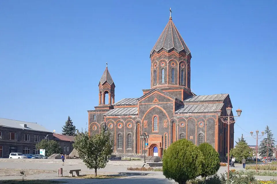
Next to the church stands a khachkar (cross-stone) memorial park built in 2010 — a collection of stone crosses that are copies of the destroyed medieval khachkars of Julfa (now in Azerbaijan). Each is in the same style but with a subtly different pattern. In the same square stands the bronze statue of Poloz Mukuch (sculptor Narek Samvelyan, 2012) — the legendary early-20th-century Gyumri street trader and comedian who became the symbol of the town’s famous sense of humour.
Surb Astvatsatsin (Yot Verk, “Seven Wounds”)
Facing Amenaprkich across the square, on the north side. Built between 1873 and 1884, its full name refers to “The Mother of God of the Seven Wounds” — the icon of the seven sorrows of the Virgin Mary that was kept in an earlier 17th-century chapel of the Kamsarakan princes on the same site.
Yot Verk is architecturally unusual for Armenia: it contains five altars for congregations of different denominations — Armenian Apostolic, Orthodox, Catholic and Assyrian. It also has an iconostasis — a rare feature in Armenian churches, dating from the period when Gyumri was a Russian imperial fortress town. The interior frescoes include a multi-figure composition of Christ on the right wall, a 17th-century mural of the Resurrection on the left wall, and a central altar image of the Madonna and Child by the painter Vardges Sureniants. Two of the church’s domes collapsed in the 1988 earthquake and still lie at the entrance as a memorial.
Kumayri historic district
The Kumayri historic-architectural reserve stretches west of Vardanants Square. It is a rare thing in Armenia and rare in the Caucasus at large: an intact block of 19th-century town houses in black and red tuff, with carved wooden balconies, closed inner courtyards and arched ceilings. The style combines Armenian tradition with the European classical architecture that shaped the town during the Alexandropol era.
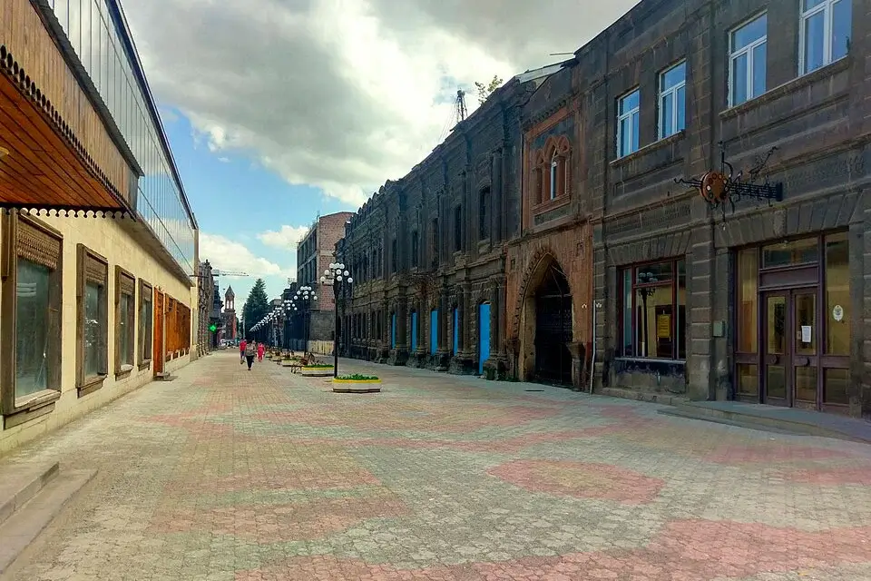
Unlike most of the rest of the city, many buildings in the Kumayri quarter survived the 1988 earthquake. Some have been restored and now house boutique hotels, guesthouses and galleries. A slow walk through the untouched blocks west of the main square is the best way to see what Gyumri looked like a hundred and fifty years ago.
Ryzhkov Boulevard
The main pedestrian street. Named after Nikolai Ryzhkov, the Soviet prime minister who coordinated the international relief effort after the 1988 earthquake. The boulevard is lined with open-air cafés, art galleries, souvenir shops and a permanent open-air art market. It ends at “Ring of Peace” Park, a recent public space. Nearby is Charles Aznavour Square, with a monument to the French-Armenian chansonnier who did more than any single individual to raise reconstruction funds for the city after 1988.
Museums of Gyumri
Gyumri takes pride in its museums — there are more than ten. The essentials:
- Aslamazyan Sisters’ Gallery — at 242 Abovyan Street, in an 1880 mansion of the Keshishov merchant family. The sisters Mariam (People’s Artist of the USSR) and Yeranuhi Aslamazyan donated more than 620 works — paintings, drawings, ceramics — to the city. Open daily except Monday, 10:00–18:00.
- Museum of Folk Architecture and Urban Life (“Dzitoghtsyan House”) — the mansion of the merchant Petros Dzitoghtsyan, built in 1872 from red tuff. Neither the 1926 nor the 1988 earthquake damaged it. Inside: furniture imported from Italy, Russia and Europe, Gyumri hand-woven rugs, photographs of old Alexandropol, and a scale model of the 19th-century town. There is also a preserved chamber of Yevgenia Dzitoghtsyan, who helped organise the Red Cross care for orphans of the Armenian Genocide. Address: 47 Akhtanak Street. Open Tuesday–Sunday, 10:00–17:00.
- Sergey Merkurov House-Museum — the childhood home of the Soviet sculptor Sergey Merkurov, native of Alexandropol, famous for creating the definitive monumental portraits of Lenin and Stalin — and for making death masks of Soviet cultural and political figures. The house is a black-and-red tuff building from 1869 with a carved wooden second-storey balcony. Inside: dozens of masks and photographs. Open Tuesday–Sunday, 11:00–17:00. Ticket around 1,000 AMD.
- Other museums. The Hovhannes Shiraz House-Museum (poet, at 101 Varpetats Street), the Frunzik Mkrtchyan Museum (the actor, at 30 Rustaveli Street — cinema on the ground floor, personal effects and costumes on the first floor), the Gyumri City History Museum on Vardanants Square, and the unusual Spider Web Art Gallery of Andranik Avetisyan.
Around Gyumri
Gyumri is known for its historic architecture, old churches and 19th-century landmarks, while several notable sites lie just outside the city. The main places are collected below, with separate detailed guides for planning each visit.
 Black Fortress (Sev Berd)
 Harichavank Monastery
 Kumayri Historic District
 Lake Arpi
 Marmashen Monastery
 Trchkan Waterfall
 Vardanants Square in Gyumri
 Yereruyk Basilica
A comfortable two-day route from Yerevan: Yerevan → Armenian Alphabet Monument → Saghmosavank → Gyumri (overnight; Vardanants Square, Kumayri walk, Black Fortress, museums) → Marmashen → Yerevan. Easiest with a car with driver from Yerevan or as a private day tour.
Who Gyumri suits
- Travellers interested in architecture and 19th-century urbanism — over a thousand preserved buildings from Armenia’s Russian imperial era, an intact historic quarter, two 19th-century churches, the Black Fortress. Nothing else like it exists in Armenia.
- Travellers interested in Soviet and post-Soviet history — Gyumri wears the story of the 1988 earthquake, the collapse of Leninakan and the long recovery under Armenian independence more openly than any other city in the country.
- Art and museum lovers — ten-plus museums including the Aslamazyan Gallery, the Merkurov death-mask collection, the Frunzik Mkrtchyan museum, the Spider Web Gallery.
- Travellers who want to understand Armenia beyond Yerevan — Gyumri shows a different country: less polished than the capital, but with a distinctive character, a famously sharp sense of humour, and a much slower pace of life.
Best time to visit
- Spring (April–May) — comfortable temperatures (+12 to +20 °C) and green fields around the town. Good time for slow walks.
- Summer (June–August) — warm but far cooler than Yerevan. Daytime around +25 to +30 °C, cooler in the evenings. Peak tourist months are July and August.
- Autumn (September–October) — mild, sunny, few tourists. The best time for photography, when the warm autumn light plays across the black tuff.
- Winter (December–February) — genuinely cold (down to −20 °C and below), but sunny. Snow-covered old streets, minimal tourist presence, and the atmosphere of a proper Caucasus mountain town. Gyumri in snow is a distinctive sight.
How to get there
Gyumri is 126 km from Yerevan on the M-1 highway — about 2 hours by car. The road is well-surfaced.
Train. Three daily commuter trains run from Yerevan’s Railway Station (50 Tigran Mets Avenue). The regular service takes about 3 hours and costs from 1,000 AMD. On Fridays, Saturdays and Sundays a fast train (№100/101) runs non-stop between Yerevan and Gyumri in about 2 hours 10 minutes.
Marshrutkas leave every hour from Yerevan’s Southern Bus Station. Journey around 2.5 hours, cost 1,500–2,000 AMD.
Direct flights. Gyumri has its own airport, Shirak International, which receives flights from Moscow (~2 h 45 min).
For a direct trip without changes, you can book a Yerevan to Gyumri transfer with pickup from your hotel, apartment or another address in Yerevan. The driver will take you directly to your hotel, apartment or another agreed address in Gyumri.
If your trip includes several stops, sightseeing along the way or travel around Gyumri and the surrounding area, a car with driver from Yerevan is a more flexible option.
Frequently Asked Questions
See more on Armenia’s cities or plan the trip with a car with driver from Yerevan.