Sevan National Park

Sevan National Park is Armenia’s largest national park and one of the most important conservation areas in the South Caucasus. It was created around Lake Sevan in 1978 and covers not just the lake itself but the surrounding shoreline, individual mountain slopes, and four separate strict-reserve zones with limited access.
Quick Facts
- Location: Lake Sevan basin, Gegharkunik Province
- Also known as: Sevan NP, Lake Sevan National Park, Sevanskii natsionalnyi park, Սևան ազգային պարկ
- From Yerevan: 65 km to Sevan town / ~1 hour
- Elevation: 1,900 m (lake surface)
- Entrance fee: Free
- Time needed: half-day for Sevanavank + viewpoints; full day with eastern shore + Noratus
- Best time to visit: May–October for warm weather; April–May and October–November for birds
- Status: National Park since 1978; Ramsar Wetland of International Importance (1993)
- GPS coordinates:
40.5507, 44.9419
This page is the conservation companion to our Lake Sevan tourist guide — beaches, monasteries, day trips, when to swim. Here we focus on the park as an administrative and ecological unit: how it was founded, what it actually covers, why its endemic species matter, the long water-restoration story, and what you can and cannot do inside.
The park is administered by the Ministry of Environment of Armenia, which runs a research centre on its territory monitoring water quality, fish populations, and migratory bird counts.
History: From Soviet Water Crisis to Protected Park
By the mid-20th century Lake Sevan was on the brink of ecological collapse. From 1933 onwards the Soviet hydroelectric programme drew heavily on the lake to feed the Hrazdan River cascade and to irrigate the Ararat Plain. By 1962 the water level had dropped by about 19 metres, the surface area shrank from 1,416 km² to 1,280 km², water temperatures rose, and algal blooms began crashing the endemic trout population.
Sevan National Park was established in 1978 to protect what remained — the freshwater ecosystem, the endemic fish species, the migratory bird populations, the shoreline plant communities, and the cultural landscapes around the lake. The park sits under the Ministry of Environment; a research centre on its grounds monitors the lake’s ecology and oversees the licensed commercial fishing quota.
In 1993, the lake and its catchment were also designated a Ramsar Wetland of International Importance — recognising Sevan’s role as a globally significant habitat for migratory waterfowl.
What the Park Actually Covers
Sevan National Park is not one continuous block of land — it’s a system of zones in and around the lake.
The lake itself is the largest single component. Some 1,240 km² of water surface at an elevation of 1,900 m. Twenty-eight rivers flow into the lake; only one — the Hrazdan, which runs through Yerevan — flows out.
The shoreline belt is a narrow strip around the lake, including ground that was former lake-bed before the 20th-century drop. These are young ecosystems still re-establishing themselves.
The four strict reserve zones are the conservation heart of the park, each with its own protection regime:
- Gilli — wetlands at the lake’s south-eastern corner, part of the Ramsar site. The most important habitat in the park for wintering and breeding waterfowl. Heavily affected by the historical water-level drop, slowly recovering since 2007.
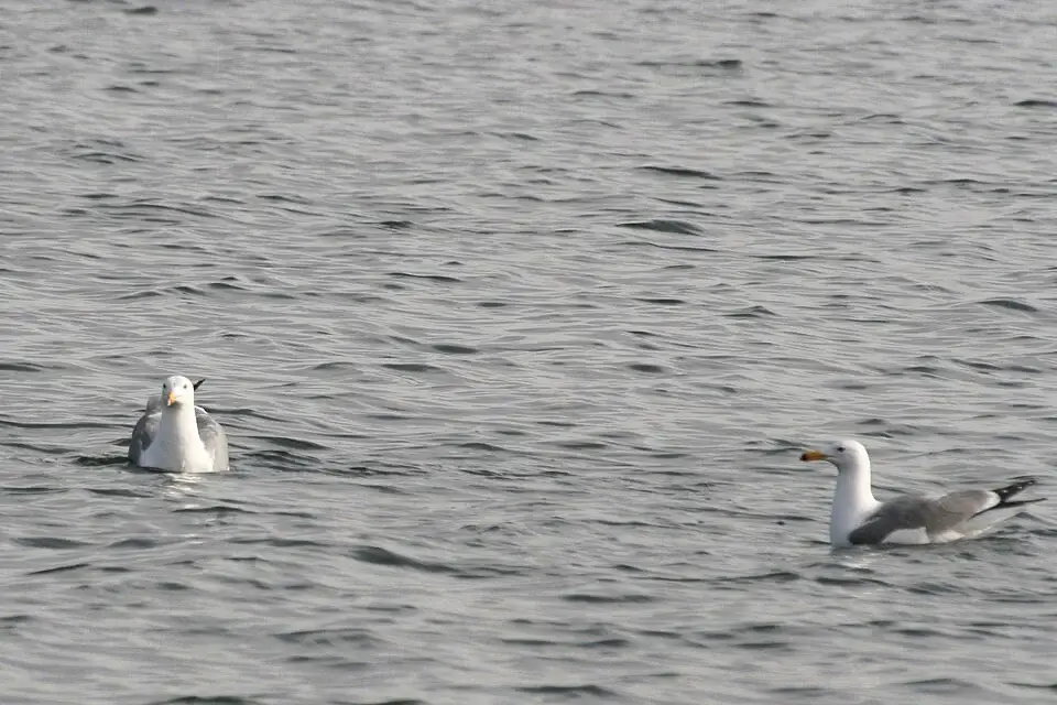
- Norashen — steppe and wetland zone on the lake’s northern shore, locally called “the island of seagulls”. It holds the world’s largest known breeding colony of the Armenian gull (Larus armenicus), the lake’s signature endemic bird.
- Lichk-Argichi — strict reserve in the southern catchment basin.
- Artanish — on the Artanish Peninsula in the lake’s north-east, protecting forest communities.
Several smaller protected sites are layered on top of these — including Gavaraget and the Gilli relict oak grove.
Endemic Species: Why Sevan Is Unique
The Sevan basin is treated by Armenian botanists as a separate floristic region — small enough to be one connected ecosystem, isolated enough that species have evolved here that grow nowhere else.
The endemic fish are what put Sevan on the conservation map:
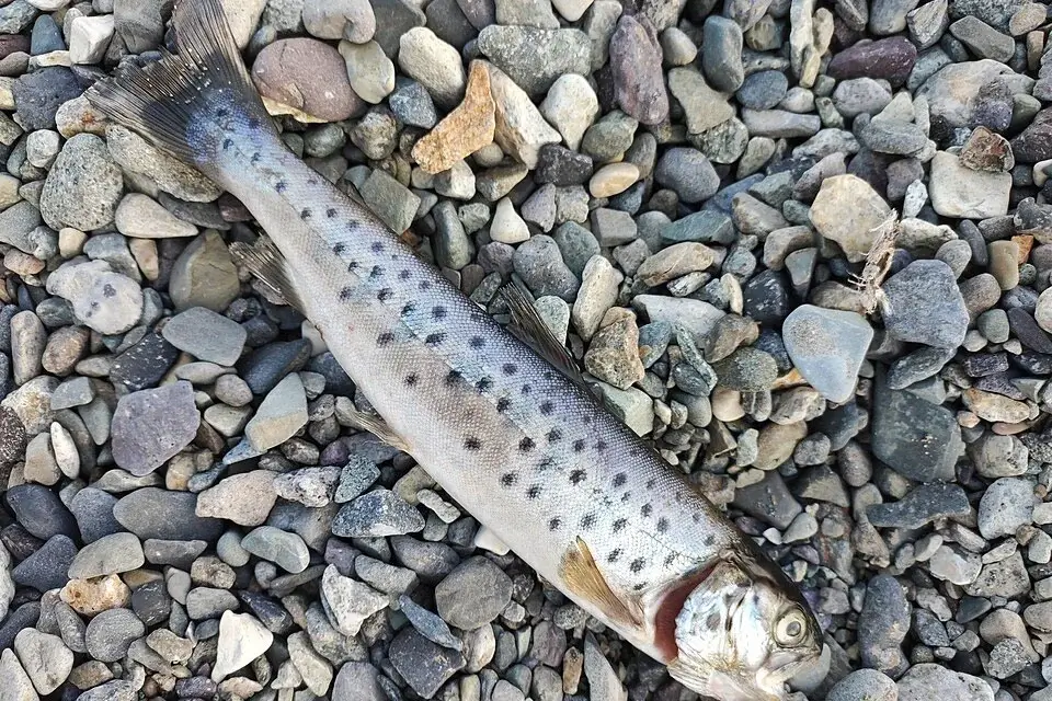
- Sevan trout (Salmo ischchan) — known locally as ishkhan, “the prince.” A lake-bound endemic, almost wiped out by the mid-20th-century collapse of the lake. Today it survives mainly through a captive-breeding programme; wild fishing is severely restricted and the species is on Armenia’s Red List.
- Sevan barbel (Barbus goktschaicus) — endemic to the lake.
- Sevan khramulya (Capoeta sevangi) — endemic to the lake and its tributaries.
Birds. Around 267 species have been recorded in the Sevan basin, with 56 in Armenia’s Red Book of Animals. Two species are regional endemics:
- The Armenian gull (Larus armenicus) — the lake’s flagship bird. The Norashen colony is the largest known breeding population anywhere.
- The mountain chiffchaff (Phylloscopus sindianus) — a small passerine of the surrounding mountain slopes.
Other notable residents and visitors include the white-tailed eagle, the Dalmatian pelican (on migration), ruddy shelduck, red-crested pochard, and various herons and grebes.
Plants. The park territory holds about 1,145 vascular plant species — and 1,587 species if you include the buffer zone. Of these, 23 are endemic to Armenia, 13 endemic specifically to the Sevan floristic region, and 17 are in the Armenian Red Data Book.
Mammals. Scientific knowledge is patchy, but confirmed residents include wolf, jackal, fox, marten, badger, European wildcat, hare, and various small rodents.
Lake Sevan’s Recovery and Current Issues
The Sevan story is the textbook conservation case in Armenia — and not a finished one.
After the 19 m water-level drop, the Soviet authorities reversed course. The Arpa–Sevan tunnel, roughly 49 km long, was built between 1964 and 1981 to divert water from the Arpa River basin into Lake Sevan. A second feeder line was later added from the Vorotan River. Together these have allowed the lake to climb back: from its 2002 low of 1,896.32 m up to 1,900.12 m in 2015 — a gain of about 3.8 metres. The level has continued to fluctuate since, depending on inflow, rainfall, and water withdrawal.
Several open conservation challenges remain:
- Eutrophication and algal blooms — every summer the lake develops blue-green algae blooms that drop dissolved oxygen and stress the trout population
- Illegal fishing — still the single biggest threat to the wild trout
- Shoreline construction pressure — tourist infrastructure development on the recovering shoreline
- Pollution — untreated runoff from lakeside towns and villages
The park’s research arm runs annual waterfowl counts, trout population assessments, and water-quality monitoring.
What’s Allowed and What Isn’t
Sevan National Park is not Khosrov Reserve — for most of the park you do not need a permit or pre-registration. The beaches, the lakeshore highways, Sevanavank Monastery on its peninsula, Noratus, and the main viewpoints are all freely accessible.
What is regulated:
- Fishing — the rules depend on species, season, and whether the fishing is recreational or commercial. Commercial fishing is licensed by the park; in spawning seasons additional restrictions and enforcement apply.
- The four strict reserve zones — access regime differs from the general lakeshore. Some sections, including parts of Norashen, may require a permit and an inspector escort. Confirm current conditions with the park administration before any visit.
- Island landings — restricted.
- Camping and campfires — permitted only at designated sites.
- Plant collection and hunting — prohibited everywhere in the park.
How to See the Park
The tourist side of the park — beaches, monasteries, day-trip planning — is covered in detail on the Lake Sevan page. The most-visited points along the M4 (western shore) and M10 (eastern shore) are:
- Sevanavank Monastery (9th c.) — on its peninsula, the postcard image of Sevan
- Hayravank Monastery (9th c.) — on the western shore
- Noratus Cemetery — the largest surviving collection of medieval khachkars in the world
- Shorja beaches — the main bathing area on the north-eastern shore
- Artanish Peninsula — for hiking and birdwatching
The standard way to reach the park from the capital is either a Yerevan–Sevan transfer for a relaxed half- or full-day visit, or a private car with driver in Yerevan for a longer loop that combines Sevanavank, Noratus, and the eastern shore in one day.


