Dilijan National Park

Dilijan National Park is one of the greenest and most forested corners of Armenia — and one of the best reasons to leave Yerevan for more than a day. The standard nickname locals and guidebooks use is “Little Switzerland“: where most of central and southern Armenia is dry highland and semi-desert, the hills around Dilijan are blanketed in dense broadleaf forest with relict Tertiary-period flora that has survived here for millions of years.
Quick Facts
- Location: Dilijan town (main access point); visitor centre in central Dilijan, Tavush Province (with parcels in Lori and Gegharkunik)
- Also known as: Dilijan Reserve, Little Switzerland, Armenian Switzerland, Դիլիջան ազգային պարկ
- From Yerevan: About 100 km / 1.5–2 hours by car
- Elevation: 1,070–2,900 m
- Entrance fee: Free
- Time needed: Full day minimum; 2 days recommended
- Best time to visit: May–October; autumn for forest colours
- Status: National Park since 2002 (founded 1958 as nature reserve)
- GPS coordinates:
40.7553, 44.8669
The park covers the basins of the Aghstev and Getik rivers along the slopes of the Pambak, Miapor, and Areguni ranges. Inside its boundaries you’ll find Armenia’s two most photogenic forest lakes, several major medieval monastic complexes, a red deer breeding centre, mineral springs, and a flagship section of the international Transcaucasian Trail (TCT). The town of Dilijan sits at the park’s geographic centre and is the natural base for any visit.
History: From Royal Forests to National Park
The Dilijan forests were protected long before the modern park existed. In the 13th century they were the holdings of the Zakarian princes, and later served as hunting grounds for Armenian meliks (regional nobles). The Dilijan State Nature Reserve was created on 13 September 1958 to protect the beech, oak, and yew forests, the pine groves, and the mountain lakes from logging and uncontrolled use.
In 2002 the territory was reorganised as a national park: the management regime softened, official hiking trails were opened, and an information centre was set up in Dilijan town. The park is now run by the Ministry of Environment of Armenia and divided into zones with different protection levels — from strictly protected core areas to recreation and economic-use zones, plus an outer buffer belt. Public access is open across most of the park, but not everywhere.
The Last Beech and Yew Forests of the Caucasus
The park’s defining feature is its relict broadleaf forest — one of the few places in the South Caucasus where these communities have survived intact. Two species dominate the canopy: Oriental beech (Fagus orientalis) and Caucasian oak (Quercus macranthera). In tucked-away pockets you’ll also find groves of English yew (Taxus baccata) — a slow-growing conifer that can live for over 2,000 years. Armenia has very few sites left where yew grows in connected stands rather than as scattered individuals; the largest one is on the park’s edge near the village of Aghavnavank.
The flora figures are remarkable for the area: around 1,150 species of vascular plants, of which seven are endemic and dozens are listed in the Armenian Red Data Book. The park sits at the intersection of the Caucasian and Armeno-Iranian botanical provinces, which is why the diversity per square kilometre is so high.
Fauna inventory:
- About 286 vertebrate species
- Mammals: Syrian brown bear, Eurasian lynx, grey wolf, fox, red deer, roe deer, wild boar, European wildcat
- Birds: golden eagle, bearded vulture (lammergeier), Caucasian black grouse, several woodpecker species
- Several species appear in the Armenian Red Data Book and on international protection lists
The park runs a Red Deer Breeding Centre in partnership with the Caucasus Nature Fund (CNF) near the Dilijan–Parz Lake road. Red deer were once native to these forests but were hunted out; the centre is rebuilding the population for eventual reintroduction. The enclosure is about 10 ha, entry is around 500 AMD, and the deer are used to visitors — children usually love it.
The Two Lakes: Parz and Gosh
The park’s two signature water features could not be more different in character.
Lake Parz (“Clear Lake”) sits at about 1,400 m, 15 km from Dilijan by road. It’s the most-visited spot in the park: a small forest lake fed by underground springs (no fish, rarely freezes), surrounded by pines, with paddle-boats, a restaurant, accommodation, and a zipline on site. Crowded on summer weekends, beautiful and quiet at all other times. Full details on the dedicated Lake Parz page.
Lake Gosh lies 22 km from Dilijan, just above Gosh village and right next to Goshavank Monastery. It’s a quieter forest lake — no boats, no zipline, often no other visitors — reached by a short, steep 1.5 km climb from the village. The classic picnic-without-the-crowds alternative to Parz. See the dedicated Lake Gosh page.
Medieval Monasteries in the Forest
Inside the park and along its margins are several important medieval complexes — most of them hidden in the trees and reached on foot.
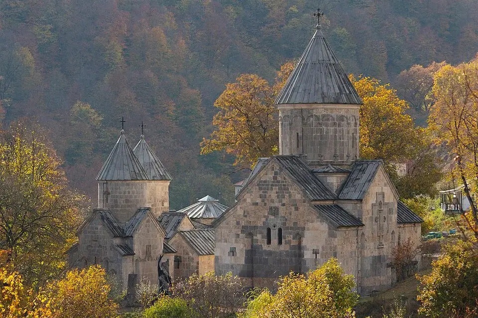
Haghartsin Monastery (10th–13th c.) is the most-visited of the park’s monasteries — and the most striking. The name roughly translates as “the dance of the eagles.” It sits in a forested cleft of the Dimats range, 12 km east of Dilijan. The complex was significantly restored in 2011 with funding from Sheikh Sultan bin Mohamed Al Qasimi, the Ruler of Sharjah (UAE), who visited and was captivated by the site. The result is one of the most polished medieval complexes in the country — close to its original 13th-century appearance. A short trail across the road from the parking area leads to a small hidden waterfall that most tour groups skip.
Goshavank Monastery (12th–13th c.) is the other great complex, in Gosh village. It was founded in 1188 by Mkhitar Gosh — the celebrated Armenian theologian, lawyer, and author of medieval Armenia’s first written legal code. The site was originally called Nor Getik (“New Getik”), replacing an earlier monastery destroyed by earthquake; it was renamed Goshavank in 1213, after Gosh’s death. The complex is famous for the finest “lace-carved” khachkar in Armenia, the work of master sculptor Poghos.
Jukhtakvank (11th c.) — “the paired monastery” — and Matosavank (also 11th–13th c.) are smaller forest ruins, easy to reach on foot from Dilijan town along marked trails. They’re slowly being reclaimed by the forest, which is part of the appeal — moss-covered walls, almost no other visitors. Aghavnavank (11th c.) sits next to the yew grove of the same name.
Hiking and the Transcaucasian Trail
Dilijan is the best hiking destination in Armenia.
The most popular routes:
- Goshavank → Lake Parz — ~7.2 km one way, moderate. Through dense beech forest with alpine-meadow openings. Part of the Transcaucasian Trail.
- Lake Parz → Dilijan — ~13.3 km, descending forest trail into town. Also on the TCT; usually done as the back half of a full day from Goshavank.
- Haghartsin → hidden waterfall — 1–1.5 km one way, easy.
- Goshavank → Lake Gosh and back — 8–9 km loop, easy to moderate.
- Dilijan town → Jukhtakvank → Matosavank — ~7 km from the town centre, the easiest monastery walk and a good half-day option.
- Mount Lchasar (2,200 m) — a full-day climb for experienced hikers.
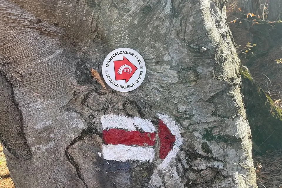
The flagship route is the 80 km Transcaucasian Trail section through Dilijan, opened in 2017 between Khachardzan village and Hovk — typically walked over 4–5 days with overnights at guesthouses or wild campsites at the lakes. It connects Goshavank, Haghartsin, both lakes, and the northern mountains in one continuous walk, and is the showcase section of the wider TCT linking Armenia with Georgia.
The visitor centre in Dilijan rents gear: tents, sleeping bags, packs, trekking poles.
⚠️ Before you head out: waymarking, bridges, and trail condition vary season to season. The TCT itself flags tricky navigation on some sections, summer shepherd dogs at upland pasture camps, mountain thunderstorms, and river crossings that swell after heavy rain.
How to Visit and When to Go
Dilijan is 100 km from Yerevan, about 1.5–2 hours by car along the M4 highway. After the Sevan Pass (2,114 m) the road dives into a tunnel and emerges in forest — the landscape changes in a single minute.
Public transport: marshrutkas leave Yerevan’s Northern Bus Station for Dilijan town 4–5 times a day. Inside the park there’s almost no public transport — Lake Parz, Haghartsin, and Goshavank all require taxis (~3,000–4,000 AMD one way from Dilijan).
For most visitors, the simpler options are a Yerevan–Dilijan transfer for an independent hiking trip, or a full-day private car with driver in Yerevan that combines Haghartsin, Goshavank, and Lake Parz in a single loop and gets you back to Yerevan by dinner.
Best time to visit:
- Late May–June — peak wildflower bloom, mild weather, waterfalls and streams at their fullest
- July–August — 5–7 °C cooler than Yerevan thanks to the ~1,500 m elevation; the standard summer escape from the capital’s heat
- September–October — golden autumn in the beech forests, the best season for photography
- Winter (December–March) — snow on the trails, lakes frozen, much of the park closed to casual hiking; Dilijan town itself remains accessible year-round and works well as a cosy winter base
Around Dilijan National Park
- Lake Sevan — 35 km away over the Sevan Pass
- Ijevan — the administrative centre of Tavush Province, 35 km north
- Yenokavan village — home to the “Yell Extreme Park” zipline and adventure complex
- Makaravank Monastery — 50 km north in the Ijevan district
- The “Drunken Forest” — a small grove near Dilijan where soil movement has left the trees leaning at odd angles
- Aghavnavank — the yew grove and the small 11th-century monastery of the same name


