Kasakh Gorge

Kasakh Gorge is one of central Armenia’s most atmospheric natural sights — and the textbook day-trip from Yerevan. The canyon runs roughly 90 km along the Kasakh River from the foot of Mount Aragats down to the Ararat Plain, and at its deepest the walls drop vertically for about 100 m. From its upper viewpoints you can take in four sacred Armenian mountains in one panorama: Aragats to the north, Ararat to the west, Mount Ara to the south, and Hatis to the east.
Quick Facts
- Location: Ohanavan & Saghmosavan villages (rim access), Aragatsotn Province (extends into Armavir)
- Also known as: Kasakh Canyon, Kasagh Gorge, Kasagh Canyon, Kasaghi Kirtch, Քասաղի կիրճ
- From Yerevan: About 35 km / 45–50 minutes by car
- Entrance fee: Free
- Time needed: 1–2 hours for viewpoints, 3–4 hours for the hike
- Best time to visit: April–May for the waterfall, spring–autumn for canyon views
- Status: Natural Monument
- GPS coordinates:
40.351174, 44.394738
The defining feature of the gorge is the marriage of wild geology with medieval architecture: Hovhannavank and Saghmosavank stand directly on the canyon’s vertical edges, reading from across the gorge as if their eastern walls were a continuation of the cliff itself.
How the Gorge Was Formed
The canyon is the product of two geological events separated by millions of years.
First came the volcanoes. Long before there was a Republic of Armenia, repeated eruptions covered the region in thick layers of lava — tuff, basalt, and andesite — that buried whole river valleys under solidified rock. Many of the older watercourses died there. A few managed to push their way back to the surface and re-cut their channels through the new volcanic cover.
The modern Kasakh River is the descendant of one of those survivors. In its upper reaches, locals still call it “the Stone Spring” — a memory of the original riverbed sealed under lava. Over thousands of years the river carved a deep canyon through the tuff, leaving the almost-vertical walls and the distinctive layered “terraces” most visible from the Hovhannavank side.
Kasakh Waterfall: A Beautiful Half-Truth
One of the most over-quoted facts about the gorge is the line about “a picturesque waterfall in the deep basalt canyon of the Kasakh River.” That description is not quite a description of a natural phenomenon, and it pays to know what you’ll actually see before you drive out.
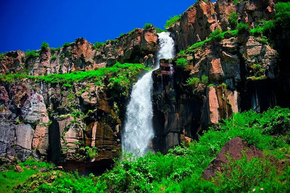
The Kasakh Waterfall is near Ohanavan village, opposite Karbi and Hovhannavank. The drop is around 20 m — making it one of the most photogenic waterfalls in Armenia when it’s running. But the water source is not natural: it comes from the Arzni–Shamiram Canal, which spills over the left wall of the gorge. After a small hydroelectric station was built here in the Soviet period, the main flow was diverted to its turbines, and today the waterfall runs only in spring, when the canal releases excess meltwater.
If you are coming specifically for the waterfall, plan for April or early May. Outside that window you will find a dry cliff face with a thin trickle, at best. Most visitors leave perfectly happy with the canyon itself, waterfall or no waterfall — but it’s worth setting expectations correctly.
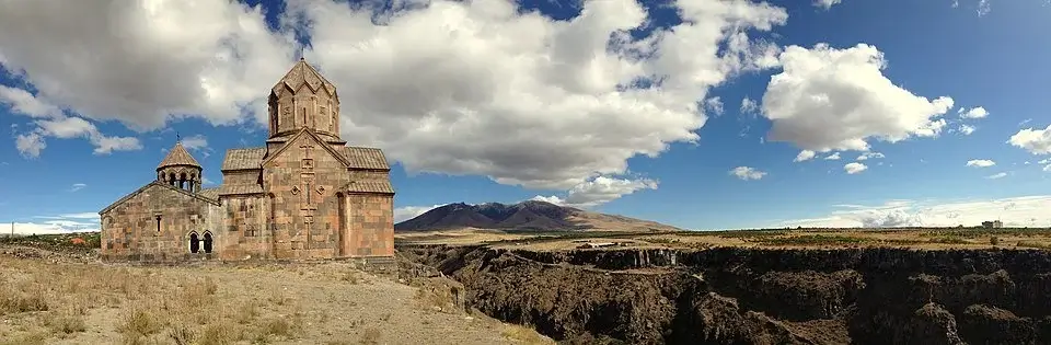
Two Monasteries on the Cliff Edges
The two great sights of Kasakh Gorge are the medieval monasteries that hang on its rim.
Hovhannavank — “the Monastery of John the Baptist” — sits over Ohanavan village on the southern edge of the gorge. Legend credits its founding to Gregory the Illuminator in the 4th century, but the surviving buildings — the main domed church of Surb Karapet and its narthex — date from the early 13th century, built under Prince Vache Vachutyan. Hovhannavank is justly famous for the bas-relief of the Parable of the Wise and Foolish Virgins above its western portal, one of the finest pieces of medieval Armenian stone-carving.
Saghmosavank — “the Monastery of Psalms” — stands 5 km north along the same cliff line, on the gorge’s northern rim. Its main church, Surb Zion, was completed in 1215, again under Vache Vachutyan. A generation later, in 1255, his successor Prince Kurd Vachutyan and his wife Khorishah added a celebrated library-scriptorium in memory of their daughter Mamkhatun — a small, jewel-box structure whose only entrance is through the library proper. In the 13th century it held some 120 manuscripts. The view from the terrace just behind the church is the most-photographed panorama of the entire gorge.
Local tradition treats the two monasteries as sister buildings, both raised by the same Vachutyan princely family in the early 1200s. A 17th-century catholicos called the surrounding gorge “the desert inhabited by angels.”
Caves, Hermits, and a Place of Refuge
Inside the canyon and along its side gullies, archaeologists have catalogued eight ancient settlements — most of them natural caves and cave complexes inhabited in the Middle Ages. Many bear the marks of deliberate human work: widened entrances, levelled floor halls, stone benches carved into the walls.
During the Seljuk and Mongol invasions of the 11th–13th centuries the monks of Saghmosavank are said to have descended into these caves to continue copying manuscripts in safety. A particularly atmospheric site between Hovhannavank and Saghmosavank is known locally as the “Red Monasteries” — a cave complex named after the reddish tone of the surrounding tuff. Some of these caves are reached on awkward, unmarked paths above sheer drops; without a guide it’s better to admire them from above than to scramble down.
The Two-Monastery Hike
The single most popular activity in Kasakh Gorge is the trail that links Saghmosavank and Hovhannavank along the canyon floor. It’s about 8 km one way, gains roughly 460 m of elevation, and most hikers take 3–4 hours with stops.
Either direction works, but local guides typically recommend starting at Saghmosavank: the descent into the canyon is steeper on that side, and finishing at Hovhannavank makes it easier to catch a taxi back to Yerevan. You’ll cross the Kasakh River, pass the small seasonal cascade and the cave-church complex, and finally climb the southern wall to Hovhannavank’s terrace.
A few practical notes:
- Spring (mid-April to early June) is the standout window — meadows in bloom, the river full, the waterfall actually flowing.
- Snakes are active in the canyon from mid-summer onwards; a long stick to clear the brush in front of you is a sensible precaution.
- After rain or snow the descent paths become slick and the river hard to cross; postpone the hike.
- The route is well marked with red-and-white blazes painted on rocks, but two short sections cross loose boulder fields where the path effectively disappears.
For most international visitors the practical way to combine the gorge with the rest of the Aragatsotn cluster is to arrange a private car with driver in Yerevan and a local trail guide — that lets you string Kasakh Gorge together with Amberd Fortress, the Armenian Alphabet Monument, or the Byurakan Observatory in a single full day.
How to Get There and When to Visit
Kasakh Gorge sits 35 km from Yerevan, about 50 minutes by car. From the city, take the Yerevan–Gyumri highway (M1); around the 28-km marker, turn left at the signpost for Hovhannavank and follow the road through Karbi to Ohanavan. From there two choices:
- Continue to Hovhannavank on the southern rim — park, walk through the monastery, and follow the trail behind it for the canyon view.
- Return to the M1 and drive another 5 km north, then turn off for Saghmosavank — the viewing terrace there is wider and the panoramic views run further.
On public transport: marshrutkas leave Yerevan’s Kilikia bus station for Ashtarak; from Ashtarak a shared taxi to Ohanavan runs around 1,500 AMD. Allow 1.5–2 hours each way
Best months:
- April–May — the only window with a flowing waterfall, green canyon floor, and clear views of Ararat.
- June–September — no waterfall, but the longest sight lines and the most reliable weather; watch for snakes on the trail.
- October — autumn colours, very few other visitors.
- Winter (November–March) — the road to Saghmosavank can close after snowfall, and the canyon descent becomes risky.
Around Kasakh Gorge
- Ashtarak — the old town of Aragatsotn, with 5th–7th-century churches and a medieval triple-arched bridge across the Kasakh River, 6 km south of Hovhannavank
- Amberd Fortress (10th–13th c.) — a fortified complex on the southern slope of Mount Aragats, 25 km away
- Byurakan Observatory — the 20th-century Soviet-era astronomical centre on Mount Aragats
- Armenian Alphabet Monument — the open-air sculpture park celebrating Mesrop Mashtots’ 405 CE alphabet, on the same Aragats road
- Lake Kari — high alpine lake at 3,200 m on Mount Aragats, the standard stop on any Aragatsotn day trip


