Lori Berd Fortress

Lori Berd (Armenian: Լոռի բերդ — “Lori Fortress”) is an 11th-century Armenian fortress-city occupying a triangular plateau between the gorges of the Dzoraget and Miskhana (Urut) rivers, about 4 km east of Stepanavan in northern Armenia. It was the capital of the Tashir-Dzoraget (Lori) Kingdom from 1065 onward and, with around 10,000 residents in the 11th–13th centuries, one of the largest cities in medieval Armenia. The walled perimeter covers about 35 hectares: a 9-hectare citadel guarded by a single defensive wall 214 m long and up to 25 m high, plus a shahastan town and outer suburbs. The city sat on the northern trade route to Ani, Dvin, Dmanisi and Tbilisi. Today Lori Berd is a state historical-cultural reserve and a republican monument under active restoration. It lies about 144 km from Yerevan (~2–2.5 hours by road via Vanadzor).
Quick Facts
- Built / Founded: 1005–1020 (capital from 1065)
- Architects: David I Anhoghin (founder)
- Location: Stepanavan (Lori Berd village), Lori Province
- Also known as: Lori Berd, Lori Berd Fortress, Lori Fortress, Lori Castle, Loru Berd, Լոռի բերդ
- From Yerevan: 144 km / about 2–2.5 hours by car via Vanadzor and Stepanavan
- Elevation: 1,490 m
- Entrance fee: Free
- Time needed: 1.5–2 hours
- Best time to visit: May–October
- Status: State historical-cultural reserve (since 2010)
- GPS coordinates:
41.003925, 44.430058
An Ancient Site Before It Was a Capital
Long before David Anhoghin chose this triangular spur, the plateau was inhabited. Excavations have uncovered Bronze Age tumulus burials of around 3,000 years ago whose grave goods point to a developed metallurgical, ceramic, and agricultural community. The Lori metallurgical centre was known for the quality of its bronze, and few sites in Armenia have yielded more metal artefacts. The road that today runs from Stepanavan toward the fortress passes a chain of these mounds along the hillsides.
The Kyurikid Capital — From Samshvilde to Lori
In the late 10th and early 11th centuries, the Kyurikids — a junior line of the Bagratid dynasty of Ani — established themselves in the Tashir and Dzoraget basins as the kingdom of Tashir-Dzoraget (also called Lori or Kyurikid). Around 1005–1020 King David I Anhoghin (“the Landless,” r. 989–1048) built a new, almost impregnable fortress-city on this promontory and moved the capital here from the older seat of Samshvilde. Archaeologists have long noted that the layout of Lori — citadel, shahastan, and outer suburbs — was modelled on the Bagratid capital of Ani itself.
In 1065, Lori was formally proclaimed the capital of the Kingdom of Tashir-Dzoraget. The city grew into a major trading hub: goods from Georgia, Persia, Central Asia, and Mesopotamia flowed through its gates on the way to Ani, Dvin, Dmanisi, and Tbilisi.
The same Kyurikid kings who built Lori were the patrons of two great monasteries 30–35 km to the east in the Debed canyon: Sanahin Monastery (consecrated 966) and Haghpat Monastery (founded 976). Together with Lori Berd, these UNESCO-listed monasteries form the visible legacy of a single dynastic project: a fortified capital backed by two royal academies in the same valley.
Sieges, Mongols, and the Long Decline
In 1105 the Seljuk emir Kizil took Lori at the cost of heavy losses; under the Georgian king David the Builder the city passed into the Georgian crown and became a base of the eastern branch of the Orbeli princely family. In 1177, Georgian King Giorgi III trapped and besieged his rebellious nephew Prince Demna here — an episode recorded in Georgian chronicles.
Under Queen Tamar the region was transferred to the Armenian prince Sarkis Zakaryan and then inherited by his sons Zakare and Ivane Amirspasalar, who restored Armenian statehood across the north-east. Under Zakarid rule a great church council was convened in Lori, attended by Mkhitar Gosh (author of the Armenian Datastanagirk law code), Khachatur Taronetsi, and other leading figures of the Armenian Church.
In 1228 the army of the Khwarazmian shah Jalal ad-Din besieged Lori, destroyed the suburbs, but failed to take the citadel. The breakthrough came in 1239, when the Mongol commander Chagatai the Elder brought siege engines and stormed the city; the treasury of Shahnshah Zakaryan was plundered. One folk version says the defenders were drunk when the walls fell.
For the next four centuries, Lori passed repeatedly between Armenian, Georgian, Turkish, and Persian rulers. The civic building inside the citadel was converted first into a mosque in the 14th–15th centuries (its qibla niche faces Mecca) and later into a church in the 18th century — a layered record of who held the ridge. The aristocratic Armenian house of Loris-Melikov descends from the later rulers of Lori. By the late 18th century the fortress had lost its military purpose; the last residents drifted away to surrounding villages.
Excavations by Yerevan State University have continued at Lori Berd since 1966. In 2010 the Armenian government declared the site a state historical-cultural reserve; restoration of the walls, the two baths, and the civic building has been under way since 2024.
Architecture — A Fortress-City on a Triangle
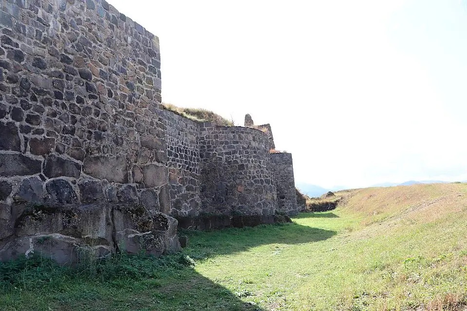
Lori Berd sits on a roughly triangular plateau at about 1,380–1,490 m. Three sides — east, south, and west — are walled by the sheer cliffs of the Dzoraget and Miskhana gorges. The only approachable side is the north-east, where the medieval engineers built one of the most ambitious defensive walls in the South Caucasus.
The fortress had the three classic parts of a medieval Armenian city: citadel (9 ha), shahastan (the walled town, 25 ha), and outer suburbs on the Amrakits and Kendagegh plateaus across the gorges, linked to the city by two bridges.
The principal surviving elements:
- Main wall — runs 214 m across the neck of the promontory, from the edge of the Dzoraget gorge to the cliff above the Miskhana. Up to 20 m thick on the Dzoraget side and 25 m high at its tallest, with alternating round and rectangular crenellated towers. The masonry is local black basalt; longitudinal wooden tie-beams were laid into the stonework for seismic resistance — a sophisticated detail for an 11th-century build.
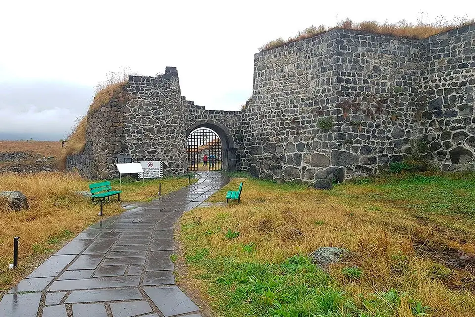
- Arched gate — the only entrance to the citadel, in the north-east corner. A moat in front of the wall was filled with water through an underground channel.
- Second defensive line — a 435 m outer wall ran about 600 m beyond the citadel to protect the shahastan; today only earth ramparts and basalt rubble remain.
- Two bath houses (11th–12th c.) — the larger 80 m south of the gate, the smaller on the edge of the Dzoraget gorge. Both used a hypocaust system of double floors and hot-air channels, the same technology found at Garni, Ani, and Amberd Fortress. Walls were lined with multicoloured glazed tile; clay pipes carried water through the masonry.
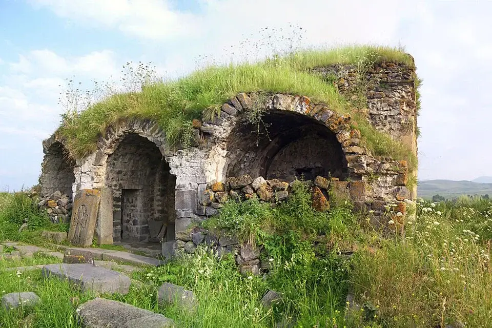
- Civic building — the only surviving structure inside the citadel. Rectangular (approximately 14 × 12 m), divided into six rooms with domes on spherical pendentives. Probably a palace originally, later converted into a mosque (its qibla niche still points to Mecca) and then a church.
- Chapel-mausoleum — traditionally attributed to David Anhoghin’s wife. The dome rose on arches supported by four pairs of columns; clay vessels were embedded in the masonry to lighten the weight — an advanced construction trick of the period.
- Medieval bridge — a single-span basalt arch bridge across the Miskhana, 11th–13th century, 9 m long and 2.8 m wide, with a pointed arch. It is widely regarded as one of the finest examples of medieval Armenian bridge-building. It was badly damaged in a 1918 flood and repaired by local residents — and has been crossed continuously ever since. A second bridge over the Dzoraget is gone; only its piers remain.
- Secret passage — an underground tunnel ran down to the Miskhana, providing drinking water and a link to the outside during siege.
- Khachkars — medieval Armenian cross-stones stand throughout the citadel.
Drinking water reached the city through clay pipes from springs 5 km away; an open-channel system fed the irrigation.
Archaeological Finds
Yerevan State University excavations since 1966 confirm Lori’s reputation as a wealthy international trading city. Recovered finds include weapons, jewellery, ceramic vessels, glass, bone, and stone work, coins of multiple eras, and — strikingly — more than 200 clay smoking pipes. Imported porcelain, faience, and luxury wares from Georgia, Persia, Central Asia, and Mesopotamia mark Lori as a true crossroads city. The bronze-age tumuli on the road from Stepanavan add the deeper, pre-medieval layer.
How to Get to Lori Berd from Yerevan
The fortress sits about 144 km from Yerevan (around 2–2.5 hours), via the M3 highway through Vanadzor and Stepanavan.
- By car: Yerevan → M3 → Vanadzor → Stepanavan → 4 km east to Lori Berd village. A paved road runs all the way to the citadel.
- By marshrutka: Yerevan → Vanadzor (~2 hours), change to a Stepanavan minibus (~40 min), then a 15-minute taxi to the site (about 1,500–2,000 AMD).
- On foot from Stepanavan: a scenic 4–4.5 km walk past the Bronze Age tumuli on either side of the road.
- With a driver: a car with driver in Yerevan lets you combine Lori Berd with Sanahin, Haghpat, and Odzun in a single day — the most efficient way to see the Kyurikid heartland in one trip.
Visiting Lori Berd — What to Know
Entry is free and the site is open year-round. There are no ticket booths; the fortress stands on open terrain at the end of a paved road. Plan 1.5–2 hours for the citadel, walls, and a descent to the medieval bridge over the Miskhana.
- Walk the full length of the 214 m wall — the basalt curtain still rises to a height of about eight modern storeys.
- Inside the citadel, look at the two ruined baths with their hypocaust floors and the civic building with its six domed bays.
- The steep, cobbled path down to the medieval bridge is the highlight; expect a 10–15 minute descent each way. Sturdy shoes are essential.
- Look for khachkars scattered through the citadel — many were recycled from earlier buildings.
- Restoration work is ongoing as of 2026; some areas may be fenced off.
- There are no cafés at the site; the nearest food and water are in Stepanavan, 4 km away.
The best months are May to October. The Lori climate is cool and damp; the gorges below can be misty in early morning, which makes for spectacular photographs.
What to See Nearby
- Stepanavan Dendropark — about 12 km away, the first forest park established in the Transcaucasus and an essential pair with Lori Berd for a full day in Lori.
- Sanahin Monastery — about 30 km east in the Debed canyon. UNESCO World Heritage; consecrated 966 under the same Kyurikid kings who built Lori Berd.
- Haghpat Monastery — about 35 km east. UNESCO World Heritage, 10th–13th c. — the twin academy of Sanahin and the second great Kyurikid foundation.
- Odzun Monastery — about 40 km away in the Debed canyon. 6th-century basilica with a unique stele monument.
- Debed Gorge — the canyon connecting all four sites, lined with cliffside monasteries, medieval bridges, and 19th-century industrial ruins.
Frequently Asked Questions
Lori Berd is the place where black-basalt walls eight storeys high still ring the neck of a triangular plateau between two canyons, where Bronze Age burial mounds line the road from Stepanavan, where a single-arch bridge built before the Mongols arrived still carries villagers across the Miskhana — and where 10,000 people once lived in the capital city of a forgotten Armenian kingdom whose two royal monasteries still stand 30 km down the valley.
To explore Lori Berd together with Sanahin, Haghpat, and Odzun in a single day from Yerevan, consider a private car with driver in Yerevan tailored to the Lori canyon cluster.


