Mount Aragats

Mount Aragats (Armenian: Արագած) is the highest mountain in Armenia and the highest peak in the Lesser Caucasus. An extinct four-peaked stratovolcano on the plain north-west of Yerevan, it carries four named summits ringed around a three-kilometre-wide crater: the Northern Summit at 4,090 metres, the Western at 3,995 m, the Eastern at 3,908 m and the Southern at 3,879 m. The standard climbing base is Lake Kari on the southern slope, a glacial tarn at roughly 3,200 metres that turns the mountain from an alpine expedition into one of the most accessible 4,000-metre objectives in the Caucasus.
Quick Facts
- Location: Aragatsotn Province
- Also known as: Aragats, Aragatz, Arakadz, Aragac, Արագած
- From Yerevan: About 70 km to Lake Kari; around 2 hours by car
- Elevation: 4090
- Entrance fee: Free
- Time needed: Full-day trip from Yerevan; 4–10 hours on trail depending on the summit
- Best time to visit: Late May–October for Lake Kari; July–September for summit hikes
- GPS coordinates:
40.5231859, 44.1946308
About the mountain
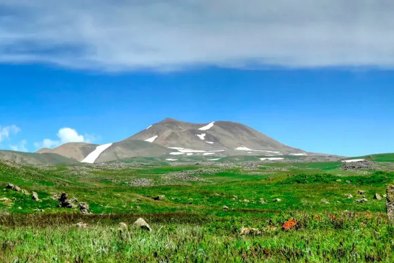
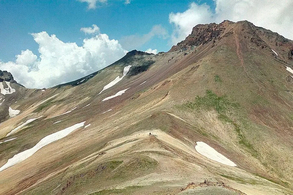
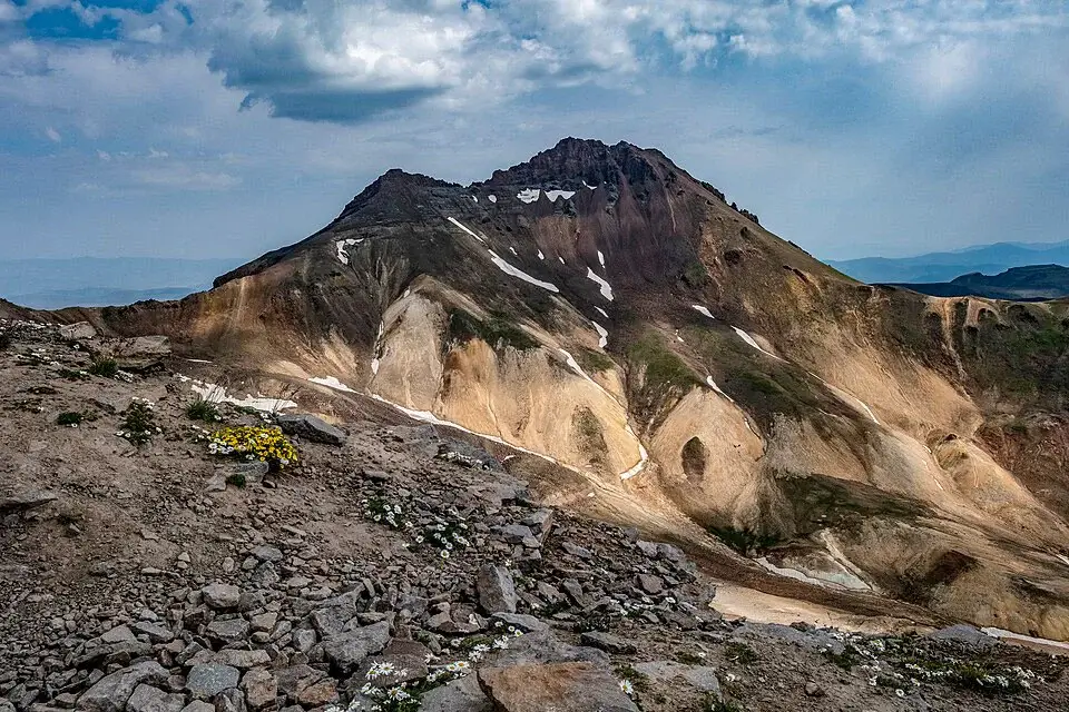
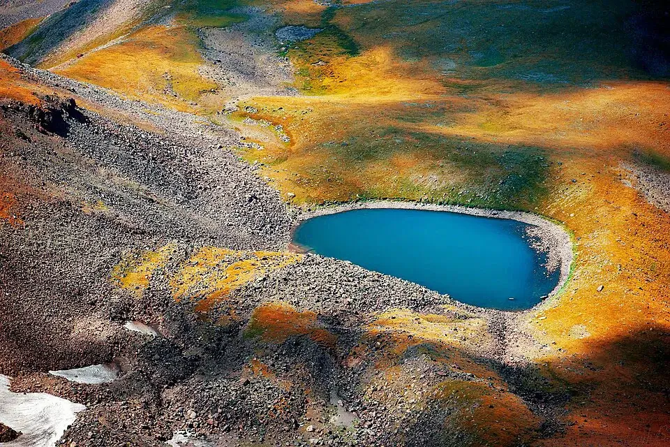
Aragats is a dormant stratovolcano sitting on an open volcanic plateau in Aragatsotn Province, with its base about 40 km north-west of Yerevan. The massif covers around 200 square kilometres — large enough that, on a long descent, the mountain seems to fold back on itself. The four named peaks rise from the rim of a central crater roughly three kilometres across and 350 metres deep; in the geological past the crater held an ice lake, and snow patches still linger inside it well into the summer.
Beyond the four main summits, the wider massif carries more than twenty secondary peaks above 3,000 metres (including Karakatar, Karapar, Kakavasar, Nigasar and Tezharuyk) and is the source of several major rivers — Gegharot, Amberd, Mantash, Narishd, Getadzor and Tsaghkahovit — all fed by snowmelt and the small glacial lakes scattered across the upper slopes. The Gegharot waterfall, on the northern flank of the mountain, is one of the highest in the country.
The Armenian name Արագած is most often translated as “Ara’s Throne” — Ara being King Ara the Beautiful, the legendary Armenian king associated with Mount Ara directly across the plain, and gah / gats meaning “throne”. An alternative etymology connects the name to Aramanyak, son of the Armenian patriarch Hayk in the older mythological cycle. The two readings sit comfortably beside each other in Armenian tradition.
The sister mountains
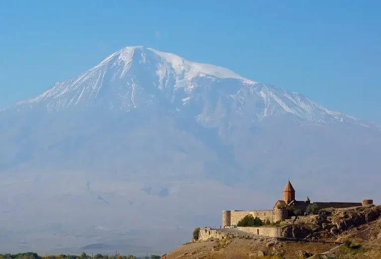
In Armenian folklore, Aragats and Mount Ararat were once sister mountains — close friends who lived side by side. After a quarrel, the legend says, they separated; Ararat moved south across the plain, and the two have stood facing each other ever since. From the summit ridge of Aragats on a clear day, the silhouette of Ararat is the dominant feature of the southern horizon — close enough that the two peaks frequently appear in the same photograph, separated only by the wide Ararat plain. For visitors who climb both Mount Ararat from the Armenian viewpoints and Aragats from Lake Kari, the legend tells itself.
The four summits at a glance
| Summit | Elevation | Round-trip from Lake Kari | Elevation gain | Time | Difficulty | Note |
|---|---|---|---|---|---|---|
| Southern | 3,879 m | 7–9 km | 650–750 m | 4–6 h | ★★☆ | Best “first Aragats”. Suitable for a single day from Yerevan. |
| Eastern | 3,908 m | 9–11 km | 750–850 m | 5–7 h | ★★☆ | A little longer than the Southern; cleanest views into the crater. |
| Western | 3,995 m | 10–12 km | 800–900 m | 5–7 h | ★★★ | Larger loose scree; careful descent. |
| Northern | 4,090 m | 14–18 km | 900–1,000 m | 7–10 h | ★★★★ | The most demanding; snow patches and cornice exposure even in summer. |
Elevation gain numbers are from the Lake Kari trailhead (3,200 m). The figures are approximate and shift with the exact line, conditions and pace.
The classic routes from Lake Kari
Most climbs on Aragats start from Lake Kari, a small high-altitude lake at about 3,200 metres on the southern slope of the mountain. The lake is reached by a sealed road through Ashtarak, Byurakan and Amberd Fortress; the road is seasonal, normally open from late May to October.
Southern Summit (the standard first Aragats)
The gentlest line to the top. From Lake Kari the trail starts on broken volcanic rubble, climbs to a long open ridge, and reaches the broad summit platform at 3,879 m after 3 to 4 hours of moving time. There is no scrambling and no exposure on the standard route; trekking poles are useful but not essential. The Southern Summit is the right choice for visitors climbing their first 4,000-metre objective, for groups with mixed fitness levels, and for anyone who wants to be back in Yerevan by evening.
Eastern Summit
Slightly longer than the Southern, with a similar character. The added distance buys the day’s strongest views into the central crater of Aragats, plus a different angle on the surrounding plain. Good as a second Aragats outing, or for hikers who want the satisfaction of an extra hundred metres of elevation.
Western Summit
The harder of the two “intermediate” summits. The upper section is dominated by loose scree that moves underfoot — the descent is more taxing than the ascent, and trekking poles become genuinely useful. The summit views toward the northern slopes are excellent.
The Northern Summit (4,090 m)
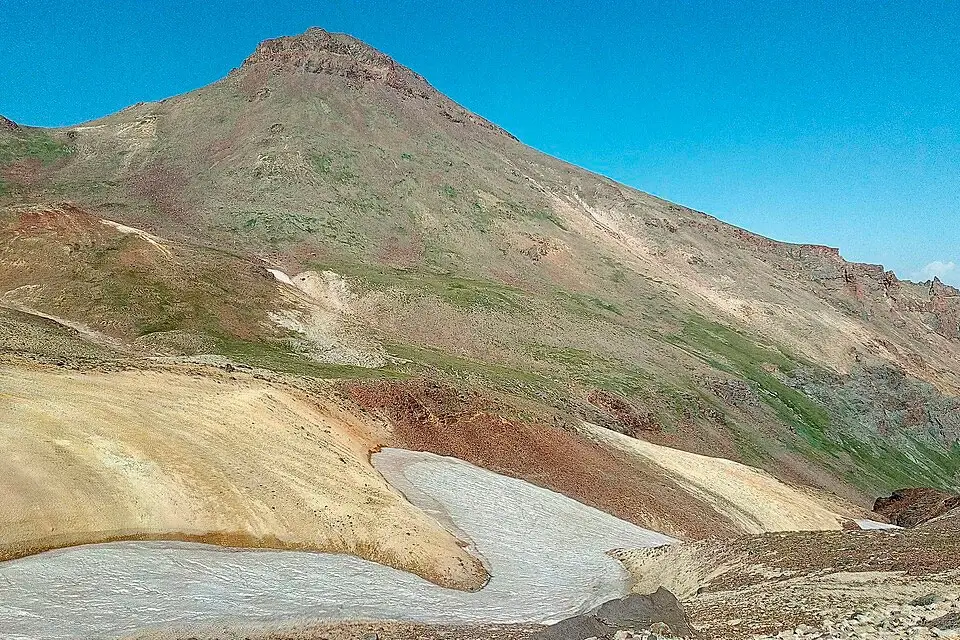
The Northern Summit is the highest point in Armenia and the most demanding of the four climbs. From Lake Kari the standard line runs around the crater rim, requires roughly 7 to 10 hours of moving time, and crosses patches of snow and scree-mixed cornice ground that can persist into August in some years. Navigation on the upper ridge is harder than on the other three summits, and the route does not have a single obvious line of cairns.
The Northern climb is most often done one of two ways:
- Direct from Lake Kari. A long day with the same trailhead as the other summits. Fit hikers can finish this in a single 7- to 10-hour push starting at dawn.
- Via the crater traverse. The most rewarding line: Lake Kari → Southern Summit → descent into the central crater → ascent of the Northern Summit → return. This is a 10- to 12-hour day and the natural choice for hikers who want the full character of the mountain.
In dry, settled weather and with previous experience at altitude, the Northern Summit is non-technical — no ropes, no exposure on the rock — but it is not a beginner climb. Cornice avoidance on the crater rim and route-finding on the upper ridge both matter. Going with a local guide is sensible if any of those factors are unfamiliar.
The four-summit traverse
For fit hikers in stable weather, the four summits can be linked in a single very long day or in a two-day round with a bivouac at the Lake Kari station. The classic chain — Southern → Eastern → Northern → Western, returning to Lake Kari — runs roughly 18 to 22 km with around 1,500 metres of cumulative elevation gain, and takes 11 to 14 hours of moving time. This is a real expedition day. Start at dawn, carry full layers, and have a hard turn-back rule for weather.
When to go
- July to mid-September. The reliable window. Snow has cleared from the access road and from most of the summit lines, daytime temperatures at Lake Kari are 10–18 °C, and storm patterns are predictable enough to plan around — most days are clear in the morning with storms building from late morning onwards.
- June. The slopes are green and the alpine flora is at its peak, but snow patches linger on the upper trails into the early summer. Micro-spikes or boot chains in the rucksack are worth packing in this month.
- October. Often the cleanest air of the year and the best long-distance views, but daylight is shorter and morning ice on the trail is common. Marginal for higher summits without winter gear.
- November to May. Out of season for normal hiking. The access road to Lake Kari is closed by snow from roughly mid-October to mid-May. The mountain becomes a full winter mountaineering and ski-touring objective, with crampons, ice axe, and avalanche skills required, and a guide non-negotiable.
In every season, start at dawn. The biggest single risk factor on Aragats is the afternoon thunderstorm cycle that builds over the massif from mid-morning in summer. The standard tactic is to be on the summit by 9 or 10 am and descending well before noon.
Difficulty and altitude
The Southern Summit is moderate. The Eastern and Western summits are moderate to hard. The Northern Summit is hard, and the four-summit traverse is expedition-grade for a single day.
A practical thought on altitude: 3,200 metres at Lake Kari is high enough that some hikers feel mild symptoms — headache, slower pace, shorter breath — even before the climb. The summits go to 3,900–4,090 metres, where the symptoms are more reliable. Pacing matters: walk slowly from the trailhead, drink water steadily, take short even breaks rather than long ones. Hikers who have not been at altitude before will manage better on the Southern Summit than on the Northern, and a guided one-night acclimatisation at Lake Kari before the summit attempt helps significantly on the higher peaks.
For comparison: on this site, Mount Hatis, Mount Gutanasar and Mount Artanish are all good warm-up climbs at moderate altitude before attempting Aragats; Mount Azhdahak on the Geghama range is a closer match for the difficulty of the Northern Summit, and Mount Khustup in southern Armenia is the natural counterpart in stamina demand.
What to bring
- Proper hiking boots with stiff ankle support; trekking poles useful on the loose upper slopes
- Mountain-grade windproof shell and warm mid-layer — the wind on the summit ridges is constant
- A second warm layer, gloves and a beanie in every season
- 2–3 litres of water per person; no reliable sources above Lake Kari
- High-calorie trail food
- Sun protection: Category 3 or 4 sunglasses (the snow above 3,500 m is highly reflective), SPF 50+ sunscreen, a wide-brimmed hat or cap
- Offline map and GPX track, head torch, power bank
- A whistle and an emergency blanket
- In June or October: micro-spikes or boot chains, gaiters
- In November to May: full winter mountaineering kit (crampons, ice axe, helmet) and a guide
Safety
- Storms. The single biggest risk factor. Storms build fast over the massif from mid-morning in summer. If cloud is rising on the southern slope, do not push for the summit — turn back early.
- Snow and cornice on the Northern Summit. Snow patches persist into August in some years, and the crater rim can be corniced. Stay back from the edge; the apparent ridge line is not always the safe one.
- Loose rock. The upper sections of all four summits have stretches of loose volcanic scree; the descent is slower than the climb. Keep 5–10 metres between hikers.
- Altitude. 3,200 metres at the trailhead is enough for the first symptoms in some hikers. Pace from the start.
- Cellular coverage. Reliable at Lake Kari, patchy on the ridges, almost absent in the crater. Do not depend on a phone for navigation.
- Sun and UV. UV at 4,000 metres on a clear day is extremely intense, especially over snow. Burning is fast.
- Lake Kari water. The lake itself is shallow and very cold; swimming is possible in summer but the water sits at glacier-melt temperature.
How to get to Mount Aragats from Yerevan
The standard approach runs Yerevan → Ashtarak → Byurakan → Amberd Fortress → Lake Kari. The road is paved as far as Amberd; from Amberd up to Lake Kari it is a sealed mountain road, normally open from late May through October. From central Yerevan to Lake Kari is around 70 kilometres and a bit under two hours of driving.
In dry conditions a standard saloon car will manage the entire route. After snow, in early or late season, a 4×4 or at least snow tyres are useful — every year a handful of cars get stopped by snow on the upper section in May or October.
Public transport reaches Byurakan but not Lake Kari. From Yerevan’s bus station, minibuses run to Byurakan (about 1 hour) and to Aparan (also 1 hour); from either, a taxi to Lake Kari costs roughly 7,000–15,000 AMD one way and the journey takes 45–60 minutes. Negotiate the return pickup in advance — there are no taxis waiting at the lake.
The simplest way for a one-day climb is with a private car with driver — early-morning departure from Yerevan, drop at Lake Kari, the driver waits while you climb, and you return to the city by evening. The same logic works as part of a private day tour from Yerevan combining the climb with a visit to Amberd Fortress on the way back.
What to see nearby
The southern slope of Aragats is one of the densest single-day cultural-natural clusters in Armenia. Within an hour of Lake Kari:
- Amberd Fortress and Vahramashen Church — 7th-to-13th-century stone complex on a rocky promontory at the confluence of the Arkashen and Amberd rivers. The most-photographed cliffside ruin in Armenia.
- Lake Kari itself — the high-altitude lake at the trailhead; an easy walk around the shore is worth twenty minutes at the start or end of the climb. Above the lake stands the Cosmic Ray Research Station of the Yerevan Physics Institute, a Soviet-era scientific facility (mostly closed to visitors but visually striking).
- Byurakan Astrophysical Observatory — on the southern slope of the mountain, founded by Viktor Ambartsumian in the 1940s and still operating; visits are possible by arrangement.
- The Armenian Alphabet Monument — the open-air park with stone letters of the Armenian alphabet, on the road from Yerevan toward Aragats.
- Saghmosavank Monastery and Hovhannavank Monastery — 13th-century twin monasteries on the rim of the Kasakh canyon, both north-east of Ashtarak.
- Aragats Gravity Hill — a small optical-illusion site on the southern road where cars in neutral appear to roll uphill; a quick novelty stop, not a destination.
- Neighbouring mountains: Mount Ara directly across the Aragatsotn plain — the legend pair — and the rest of the mountains in the Armenian mountains umbrella.
Frequently asked questions
Mount Aragats is the natural high point of any active trip to Armenia — close enough to Yerevan to climb in a single long day, large enough to offer four genuinely different summit experiences, and high enough that the view from the top is unlike any other mountain in the country. Pick the Southern Summit for a first taste, the Northern for the real prize, and any of the four-summit traverse variants if you want a day you remember.