Mount Khustup

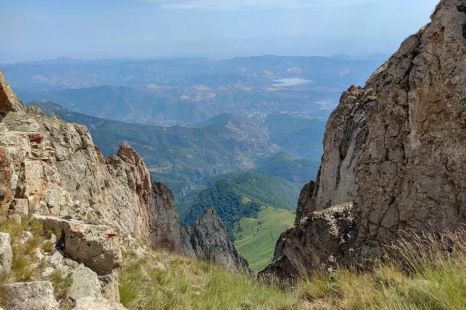
Mount Khustup is the highest summit of the Khustup–Katar range in southern Armenia, a 3,206-metre wall of basalt and limestone rising directly over the town of Kapan in Syunik Province. It is one of the longest, hardest day-hike summits in the country, a sacred mountain in Armenian folk tradition since long before Christianity, and the kind of climb where strong panoramas over the Zangezur range, the Vorotan valley and the Iranian border ridges become the reward for a serious morning’s work.
Quick Facts
- Location: Syunik Province
- Also known as: Khostup, Hustup, Khustup Mountain, Խուստուփ
- From Yerevan: About 320 km; 6–7 hours one way
- Elevation: 3,206 m
- Entrance fee: Free
- Time needed: 2-day hike; 5–7 hours on foot with 4×4 shortcut
- Best time to visit: July–mid-September
- GPS coordinates:
39.1366526, 46.3298418
About the mountain
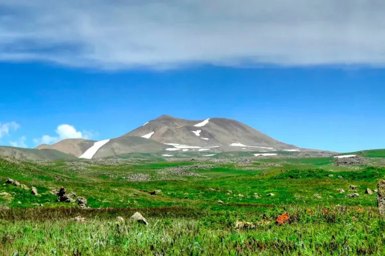
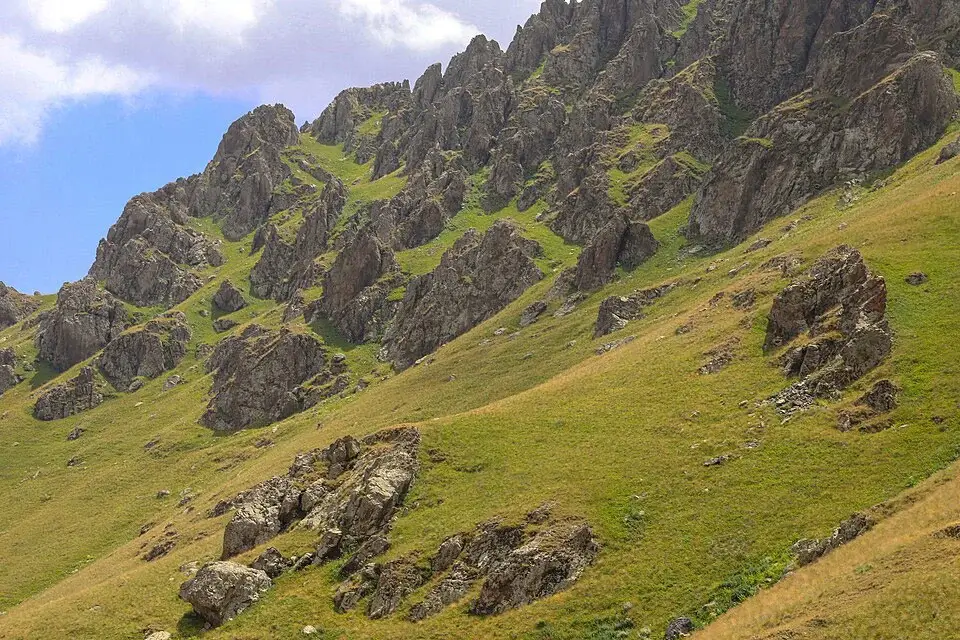
Khustup stands 9 km south-west of the town of Kapan, the regional centre of southern Armenia’s Syunik Province. The mountain is the highest peak of the Khustup–Katar range, part of the broader Zangezur mountain system that forms the spine of southern Armenia. Geologically it is built from volcanic and sedimentary rock — chalk volcanic upper slopes resting on a subsurface of porphyrite, marlstone and limestone — and the slopes are sharply fractured, with scars and small caves spread across the higher pitches.
Three rivers begin on Khustup’s slopes: the Vachagan and Geghanush drop east toward the Voghji, and the Shishkert drops south-west toward the Tsav. The lower slopes are forested on the north-eastern side; the upper slopes carry alpine meadow, and snow patches linger in the high cirques well into early summer.
The name “Khustup” is thought to come from the root khutu, meaning “prayer” in an old Indo-Iranian language family — the etymology is consistent with the mountain’s long use as a sacred site. A spring near the summit was a focus of pre-Christian Armenian pilgrimage, originally associated with the goddess Astghik and the water festival of Vardavar. The annual pilgrimage to the sacred spring on the day of Vardavar has been continuous for centuries, has survived the country’s conversion to Christianity, and continues today: every year, families from the surrounding villages walk up to the spring in mid-summer, with picnics on the lower meadows and ritual water-splashing in the older folk tradition.
The trail to the summit
There are several reasonable lines to the top, and the choice of route changes the day’s difficulty profile significantly. The three most common approaches:
1. Baghaburj (the classic line). The trail starts at Baghaburj village, four kilometres south of Kapan, and runs about ten kilometres one way to the summit. The total elevation gain from the village is around 2,200 metres — among the largest day-hike elevation gains in Armenia. Most parties split this over two days, with a base camp on the meadow above Storot at roughly 2,300–2,500 metres. The trail is well-defined, with red-and-white waymarkers on the upper rocky sections.
2. Storot or other high-clearance access (shortened route). A 4×4 vehicle can reach roughly the 2,000–2,300 metre line above Kapan in dry conditions, cutting the climb to about 1,000 metres of elevation gain on foot and 5–7 hours of moving time. The drive itself is rough — high-clearance vehicle required in dry weather, full 4×4 essential after rain. This is the format used by most one-day organised climbs.
3. Tsav (south-western approach). A longer alternative that starts on the southern side, runs about 28 kilometres up and down, and is used as a multi-day backpacking line on the Transcaucasian Trail’s southern sections. Suitable for experienced hikers with full camping gear.
Trail at a glance (classic two-day from Baghaburj):
- Day 1: Baghaburj → camp above Storot, ~5–6 hours moving, ~1,400 m elevation gain
- Day 2: camp → summit → return to camp / Baghaburj, ~6–8 hours, ~800 m further gain
- Total round-trip distance: ~20–22 km
- Total elevation gain: ~2,200 m
- Difficulty: moderate-to-hard; serious cumulative load
- Best season: July to September
Water on the trail. Two reliable water points on the standard line: one at the camping meadow above the village, and a second roughly an hour above the camp on the trail itself. Both can shrink by late summer — carry a litre or two from the trailhead as insurance.
When to go
- July to mid-September. The reliable window. Snow has cleared from the upper slopes, the access road dries out, and the alpine meadows are at their fullest. July in particular is the peak month for the alpine flora — Khustup is one of the richest wildflower mountains in southern Armenia. August and early September have the most stable weather.
- May and June. Possible, but the upper slopes still hold snow patches in the cirques, the access road from Kapan is often muddy, and morning ice can lock the trail at altitude. Climbs are doable but need full shoulder-season kit.
- October. Brief golden-autumn window with short daylight and increasing risk of cold fronts. Reasonable for fit hikers in stable forecasts, marginal otherwise.
- November to April. Out of season. The mountain holds snow on the upper slopes and the weather is consistently stormy in winter. Climbs in this period are full winter mountaineering objectives with avalanche risk on several lines.
Difficulty and who the hike suits
Khustup is moderate-to-hard, and one of the more demanding day-hike summits in Armenia. The single biggest factor is the total elevation gain: 2,200 metres from Baghaburj is at the top end of the range that any reasonably fit hiker can manage in a single day, and even on the 4×4 shortcut the upper 1,000 metres are sustained climbing on rocky terrain. Other factors that drive the difficulty:
- Distance. 20–22 km round-trip on the classic two-day; ~12–14 km on the 4×4 shortcut.
- Loose rock on the upper sections. The summit cone is loose volcanic scree that moves underfoot; trekking poles help on the descent.
- Weather exposure. The summit ridge is open in all directions, and afternoon thunderstorms over the Zangezur range build fast in mid-summer.
- Remoteness. The trailhead is 320 km from Yerevan — far enough that an early-morning summit attempt usually means an overnight in Kapan the day before. Cellular coverage is patchy from the base camp upwards.
Honest grade: a comfortable two-day hike for experienced trekkers; a serious one-day push for fit hikers with the 4×4 shortcut and a 5 am start. For a first Armenian mountain experience, Mount Hatis, Mount Gutanasar or Mount Artanish are better warm-ups; the natural next step up in elevation and commitment is Mount Azhdahak on the Geghama range.
What to bring
- Proper hiking boots with stiff ankle support; trekking poles useful on the loose upper slopes
- A real windproof shell and warm mid-layer; the summit catches wind from both sides of the ridge
- A second warm layer, gloves and a beanie even in midsummer
- 2 litres of water per person between water points; refill at every reliable source
- High-calorie trail food (the day is long)
- For the two-day format: full camping kit — tent, sleeping bag rated for sub-zero summit nights, stove
- Offline map and GPX track, head torch, power bank
- Sun protection: high-SPF sunscreen, Cat 3 sunglasses, a hat — UV at 3,200 m is intense
- A whistle and a light emergency blanket
- In early or late season: micro-spikes or boot chains for icy mornings, waterproof gaiters
Safety
- Lightning. Afternoon storms are common in July and August over the Zangezur range. The summit is fully exposed; if cloud is building, turn back without going for the top. The standard tactic is a pre-dawn start so that the summit attempt finishes by mid-morning.
- Loose scree on the descent. The upper third of the trail has stretches of loose volcanic rock; the descent is slower and harder than the climb. Keep 5–10 metres between hikers and watch your footing.
- Fog and navigation. The trail braids in places and the upper waymarkers are spaced further apart than on more popular Armenian peaks. In fog, stop and wait it out rather than guessing.
- Wind chill on the summit. Temperatures on the summit can fall below freezing on a windy summer afternoon, even when the trailhead is 25 °C.
- Cellular coverage. Reliable in Kapan, patchy on the lower trail, almost absent above the base camp. Do not depend on a phone for navigation.
- Bears and other wildlife. The forested lower slopes are habitat for brown bears, wild boar and the occasional Caucasian leopard track. Encounters are rare, but make noise on the wooded sections so animals can move out of your way.
How to get to Mount Khustup from Yerevan
The mountain is in the deep south of Armenia: 320 km from Yerevan via the M-2 highway through Goris and on to Kapan, 6 to 7 hours of driving in normal conditions. Most parties travel down the day before the climb and overnight in Kapan or in a guesthouse near Baghaburj.
From Kapan a paved road runs the four kilometres to Baghaburj. Beyond that the access road climbs onto the mountain on dirt and gravel, with the road quality dropping the higher you go. In dry weather a careful driver can reach roughly the 1,800-metre line in a saloon car; for the higher trailhead, around 2,000–2,300 metres, a 4×4 is required in every season, and after rain it is non-negotiable.
Public transport reaches Kapan but not the trailhead: minibuses from the bus station in Yerevan run daily, with the journey taking 6–7 hours. From Kapan onward you will need a local 4×4 transfer or a pre-booked vehicle.
The simplest way to plan this climb is with a private car with driver booked for two or three days from Yerevan, or as part of a private tour from Yerevan that combines Khustup with the Tatev–Goris cluster on the way down. Khustup is one of the climbs where a local guide adds real value, particularly for the route-finding on the upper slopes and for reading the weather.
What to see nearby
Khustup sits inside one of the richest and least-visited regions of Armenia. Worth combining with:
- Tatev Monastery — the great 9th-century monastery on a cliff above the Vorotan gorge, reached on the world’s longest reversible aerial tramway. The natural cultural anchor of any Syunik trip.
- Shaki Waterfall — an 18-metre fall near Sisian, on the route between Yerevan and Kapan.
- Goris — historical town with old cave dwellings, two and a half hours north of Kapan; a comfortable overnight stop on the way down.
- Old Khndzoresk — the cliff-side cave village south-east of Goris, with the famous suspension footbridge across the gorge.
- Zorats Karer (Carahunge) — the prehistoric standing-stones site near Sisian.
- Halidzor Fortress — 17th-century military complex just north of Kapan.
- Vahanavank Monastery — 10th-century monastery in a forest setting near Kapan.
- Neighbouring peaks of the southern range: continuations of the Khustup–Katar massif rise immediately east and south, with longer multi-day options on the Transcaucasian Trail for committed backpackers.
Frequently asked questions
Mount Khustup is not a beginner’s mountain. It is the kind of summit that visitors with mountain experience come south specifically to climb, and that pairs naturally with the cultural circuit of Syunik — Tatev, Goris, Khndzoresk — for a long, ambitious weekend out of Yerevan.