Smbataberd Fortress

Smbataberd (Armenian: Սմբատաբերդ — “Fortress of Smbat”) is a medieval Armenian fortress crowning a narrow mountain ridge at about 2,000 m, between the villages of Artabuynk and Yeghegis in Vayots Dzor Province. It is one of the largest and best-preserved fortresses in Armenia — a 6.5-hectare stronghold ringed by basalt walls with semi-circular bastions. The earliest fortification on this ridge may pre-date the 5th century and is sometimes linked to the Battle of Avarayr (451); the visible walls belong mostly to the 9th–11th centuries, with major reinforcement under the Orbelian dynasty in the 13th century. In its entire history Smbataberd fell only once — not by force, but by a thirsty mule. It lies about 140 km from Yerevan (around 2.5–3 hours by road) and reaches the Yerevan visitor mainly as the trailhead for one of Vayots Dzor’s classic day hikes.
Quick Facts
- Built / Founded: Before 5th c. (main construction 9th–11th c.; Orbelian reinforcement 13th c.)
- Location: Artabuynk / Yeghegis, Vayots Dzor Province
- Also known as: Smbataberd, Smbataberd Fortress, Smbataberd Castle, Smbataberd Berd, Սմբատաբերդ
- From Yerevan: About 140 km / 2.5–3 hours by car
- Elevation: 2,000 m
- Entrance fee: Free
- Time needed: 2.5–5 hours (depending on route)
- Best time to visit: Late April–early June; mid-October–December
- Status: Protected historical-cultural reserve (since 2018)
- GPS coordinates:
39.8717374, 45.3384059
A Fortress Older Than Its Name
The fortress on this ridge is much older than the name “Smbataberd” attached to it. Some scholars identify the site with Symbace, a stronghold mentioned by the Greek geographer Strabo in his Geography, which would place an Armenian fortification here well before the 5th century. Medieval chronicles also tie the fortress to the Battle of Avarayr in 451, when Armenian forces under Vardan Mamikonian resisted Sasanian Persia. Until the 7th century the site served as the military headquarters of the Vasakyan princely house, the regional branch of the Syunik dynasty whose civilian capital was Yeghegis.
According to the historian and archaeologist Sedrak Barkhudaryan, Smbataberd, Yeghegis, and the nearby Tsakhats Kar Monastery formed a single architectural, spiritual, and political whole — the regional center of the Yeghegis-based Syunis.
Prince Smbat, Smbat Orbelian, and the Question of the Name
The name “Smbataberd” first appears in local tradition and is connected to more than one Prince Smbat. The most likely figure is the 10th-century Syuni prince Smbat, whose resistance is recorded by the historian Stepanos Orbelian: in 922, when the general Nasr attacked Syunik on the orders of the Sajid amir Yusuf ibn Abi’l-Saj, Prince Smbat organised the defence from Yeghegis and repelled the assault. Other scholars link the name to Smbat II Tiezerakal Bagratuni, who fortified defensive works of this scale in the same century, or to Smbat Orbelian (r. 1251–1273), who was buried in nearby Yeghegis after rebuilding the citadel.
Smbat Orbelian himself was an extraordinary figure: he spoke five languages, negotiated directly with the Mongol khanate, and secured the lifting of tribute on Armenia and the return of lands previously confiscated from monasteries. Under his rule, Smbataberd was extensively expanded and reinforced into the form that survives today.
In 1605, during the Ottoman–Safavid wars, the army of Shah Abbas I finally destroyed the stronghold. After that, Smbataberd was abandoned. Restoration began in 2006–2007 and was resumed in 2011 by Armenia’s Ministry of Culture; in June 2018 the government declared the site a protected historical-cultural reserve.
Architecture — The “Armenian Great Wall” on a Knife-Edge Ridge
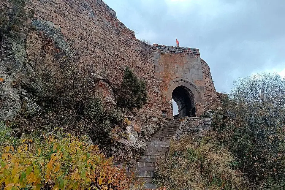
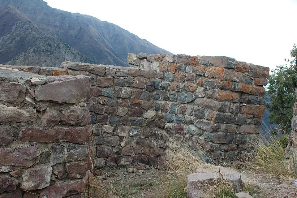
Smbataberd occupies a narrow ridge on a south-western spur of the Vardenis Range. Three sides — east, west, and south — drop into the gorges of the Yeghegis and Artabuynk rivers; the fourth side is reached only across a single narrow saddle. Despite this natural protection, the builders ringed the entire perimeter with double lines of high pyramidal walls — a continuous curtain that hikers today still trace from bastion to bastion. Among Armenian hikers the site is sometimes called the “Armenian Great Wall of China”.
Key elements:
- Walls built of wedge-cut black basalt set in lime mortar, 8–10 m high and 2–3 m thick, running the entire perimeter.
- Semi-circular bastions at regular intervals — originally crowned by twelve watchtowers, 10–11 m high and 3–4 m wide.
- Three gates — the main one on the north-east, plus north-western and northern entrances — built of dressed basalt in corridor form, with guard chambers and rooftop observation posts.
- An internal cross-wall divides the fortress into a northern and southern compound; in each are the ruins of citadels, barracks, dwellings, and water cisterns.
- The water supply was the fortress’s only weakness: water arrived through an underground clay pipe from springs near Tsakhats Kar.
The Legend of the Salted Mule
Smbataberd was taken only once in its history — and not by force. The story, which exists in two versions (Seljuk-era or 16th-century Persian invaders), runs as follows.
A besieging army that could not breach the walls remembered an old trick. They withheld water from a mule for several days, then fed it salt and released it to wander in the hills around the fortress. The maddened animal sniffed out the underground clay pipe carrying water from Tsakhats Kar and began digging at the surface above it. The besiegers found the line, cut it, and waited. Within a week the garrison — with no other source of water on the bare ridge — was forced to surrender.
It is one of the most widely told legends of any Armenian fortress, and the reason the pipe-route between Tsakhats Kar and Smbataberd is pointed out by every local guide.
Tsakhats Kar Monastery — Smbataberd’s Spiritual Twin
About 800 m north-east of the fortress, on a neighbouring hillside, stands Tsakhats Kar Monastery (Armenian for “Painted Stone”). The complex comprises three churches — Surb Nshan, Surb Karapet (1041), and Surb Astvatsatsin — and was a medieval centre of painting and manuscript illumination. The walls of Surb Karapet preserve bas-reliefs with the heraldic emblems of the Syunik princely houses (9th–11th centuries). A partial reconstruction was carried out in 2013.
Together, Smbataberd and Tsakhats Kar formed a single defensive-spiritual unit: the fortress shielded the region, the monastery housed its schools and scribes, and the spring water that flowed beneath the saddle linked the two.
Yeghegis — the Medieval Capital Below
To understand what Smbataberd defended, walk down to Yeghegis village in the valley. In the Middle Ages this was the administrative seat of Vayots Dzor and the residence of the Syunik princes; Smbat Orbelian himself is buried here. Yeghegis also preserves a rare medieval Jewish cemetery (13th–14th centuries) with tombstones inscribed in Hebrew and Aramaic — evidence that the town hosted a cosmopolitan trading community at the height of Orbelian rule.
The Hike — Routes from Artabuynk and Yeghegis
The fortress is reachable only on foot or by 4×4 along a gravel track. There are two starting points:
- From Artabuynk (west) — the standard short hike. About 2 km up on a jeep track, 1–1.5 hours to the gate. Trail crosses a bridge at the edge of the village, then climbs steadily to the saddle and the main north-east entrance. Most hikers come this way and return the same path.
- From Yeghegis (east) — a slightly gentler but longer approach, about 3–4 km one way. The classic loop combines both: Artabuynk → Smbataberd → Tsakhats Kar → Yeghegis, around 10–12 km and 4–5 hours with stops.
Best season: late April to early June (wildflowers) and mid-October to December (golden landscape, cool temperatures). Summer is hot and exposed, with reported temperatures around +35 °C and increased snake activity on the slopes. Winter brings snow from late December to late February — beautiful but more demanding. The trail is largely unmarked; a GPS file or offline map (HIKEArmenia, Wikiloc) is recommended.
Watch the cliffs above the fortress for bezoar goats — wild ibex relatives that often appear in groups along the ridge.
How to Get to Smbataberd from Yerevan
The fortress sits about 140 km from Yerevan, mostly along the M2 highway toward Yeghegnadzor, then a 12 km local turn-off to Artabuynk.
- By car: Yerevan → M2 → Yeghegnadzor → Artabuynk village (about 2.5–3 hours). Park at the edge of the village near the “Artabuynk” sign.
- By marshrutka: From Kilikia Bus Station in Yerevan, buses run to Jermuk (about 2,500 AMD) or to Yeghegnadzor; from either, a taxi to Artabuynk is needed (around 5,000–7,000 AMD from Yeghegnadzor).
- With a driver: a car with driver in Yerevan lets you combine Smbataberd with Noravank, Areni-1 Cave, Orbelian’s Caravanserai, and Jermuk in a single day from Yerevan — the most efficient way to see the Vayots Dzor cluster without a 4×4.
Bring water and snacks — there are no cafés or shops at the trailhead — and wear proper hiking shoes. The summit panorama opens a full 360° onto the Vayots Dzor mountains, the Yeghegis gorge, and the Vardenis Range.
What to See Nearby
- Tsakhats Kar Monastery — 800 m north-east of the fortress; three 10th-century churches, princely heraldic bas-reliefs.
- Yeghegis village — medieval Jewish cemetery, Zorats Church, and the tomb of Smbat Orbelian.
- Noravank Monastery — about 25 km away in the red-cliff Arpa gorge, one of the masterpieces of 13th-century Armenian architecture and the dynastic centre of the Orbelians who fortified Smbataberd.
- Orbelian’s Caravanserai (Selim Caravanserai) — about 25 km north on the Vardenyats Pass (2,410 m), built in 1332 by Prince Chesar Orbelian on the same family network that re-armed this fortress.
- Areni-1 Cave — about 40 km away; home to the world’s oldest known winery (~6,100 years) and the oldest known leather shoe.
- Jermuk Waterfall — about 30 km away, in the spa town famous for its mineral springs.
- Gndevank Monastery — about 15 km away in the Arpa River gorge, 10th century.
Frequently Asked Questions
Smbataberd is the place where a continuous black-basalt curtain still rings a knife-edge ridge at 2,000 m, where the Orbelians built one of medieval Armenia’s most ambitious strongholds, and where the only siege ever to break it ended with a salted mule and a broken clay pipe. The walls are still here; the panorama from them — Vayots Dzor in every direction, Yeghegis far below — explains in one look why this particular ridge was worth defending for fifteen centuries.
To explore Smbataberd together with Noravank, Areni-1, and Jermuk in a single day from Yerevan, consider a private car with driver in Yerevan tailored to the Vayots Dzor cluster.


