Yereruyk Basilica

Yereruyk Basilica (Armenian: Երերույքի տաճար, Yereruyk’i tachar) is one of the earliest surviving Christian buildings in Armenia — a ruined paleo-Christian basilica of the 4th–6th centuries on a plateau above the Akhurian river, near the village of Anipemza in Shirak Province, 130 km north-west of Yerevan. Built of pink-orange tufa on a remarkable six-step stone stylobate, with tall corner towers and a Greek inscription that echoes contemporary churches in Syria, it stands today roofless and largely silent — high walls and arched openings open to the sky, in the wind of the Shirak plateau.
Quick Facts
- Built / Founded: 4th–6th c.
- Location: Anipemza village, Shirak Province
- Also known as: Yereruyk Basilica, Yererouk Basilica, Ererouk Basilica, Yereruyk Temple, Երերույքի տաճար, Երերույք
- From Yerevan: ~130 km (2–2.5 hours by car)
- Entrance fee: Free
- Time needed: 45–60 minutes
- Status: Ruined early Christian basilica; UNESCO Tentative List
- GPS coordinates:
40.4395132, 43.6091472
The Akhurian river below the basilica forms the border with Turkey, and the silhouette of medieval Ani — the ruined Armenian Bagratid capital that once held more than 100,000 people — sits five kilometres away on the opposite bank, visible from the platform around the church. In 1995 Yereruyk was inscribed on the UNESCO World Heritage Tentative List, recognised as one of the most important pre-Arab Armenian basilicas and a key witness to the early relationship between Armenian and Syrian Christian architecture.
A short history: between Armenia and Syria
No medieval Armenian text mentions Yereruyk by name — an unusual silence for a building of this size and stature. The dates of its construction therefore come not from documents but from the evidence of the building itself: stratigraphic excavation, the style of the sculpted decoration, and the patterns of comparable Syrian churches in Turmanin (5th century), Qal’at Sem’an (late 5th century) and Rusafa (7th century). The current consensus places the start of construction in the 4th century, a pause through the 5th, and final completion in the 6th.
The basilica is traditionally associated with the Kamsarakan princes, the noble Armenian family that controlled this part of Shirak in the early medieval period. Around the church a substantial settlement grew up: 20th-century excavations have uncovered underground chambers, a water reservoir (its medieval weir found in 1948), dwellings, and tunnels leading down to caves in the Akhurian gorge below.
The pioneering Armenian architectural historian Toros Toramanian, who surveyed Yereruyk at the end of the 19th and the beginning of the 20th century, called it possibly the earliest example of a columned basilica in Armenian church architecture — a foundation stone of the entire tradition. Modern scholars including Patrick Donabédian, whose 2024 chapter on the site appears in the World Heritage Sites in Armenia volume, continue to refine the chronology.
A surprising find came from a 2011 excavation campaign. A large grave with seven or eight pedestals was uncovered near the basilica, containing the remains of numerous newborns. Archaeologists have suggested a link with a possible early dedication of the church to John the Baptist: in early Christian tradition unbaptised infants were sometimes interred by the walls of a church for the salvation of their souls.
Architecture: Syrian features on Armenian ground
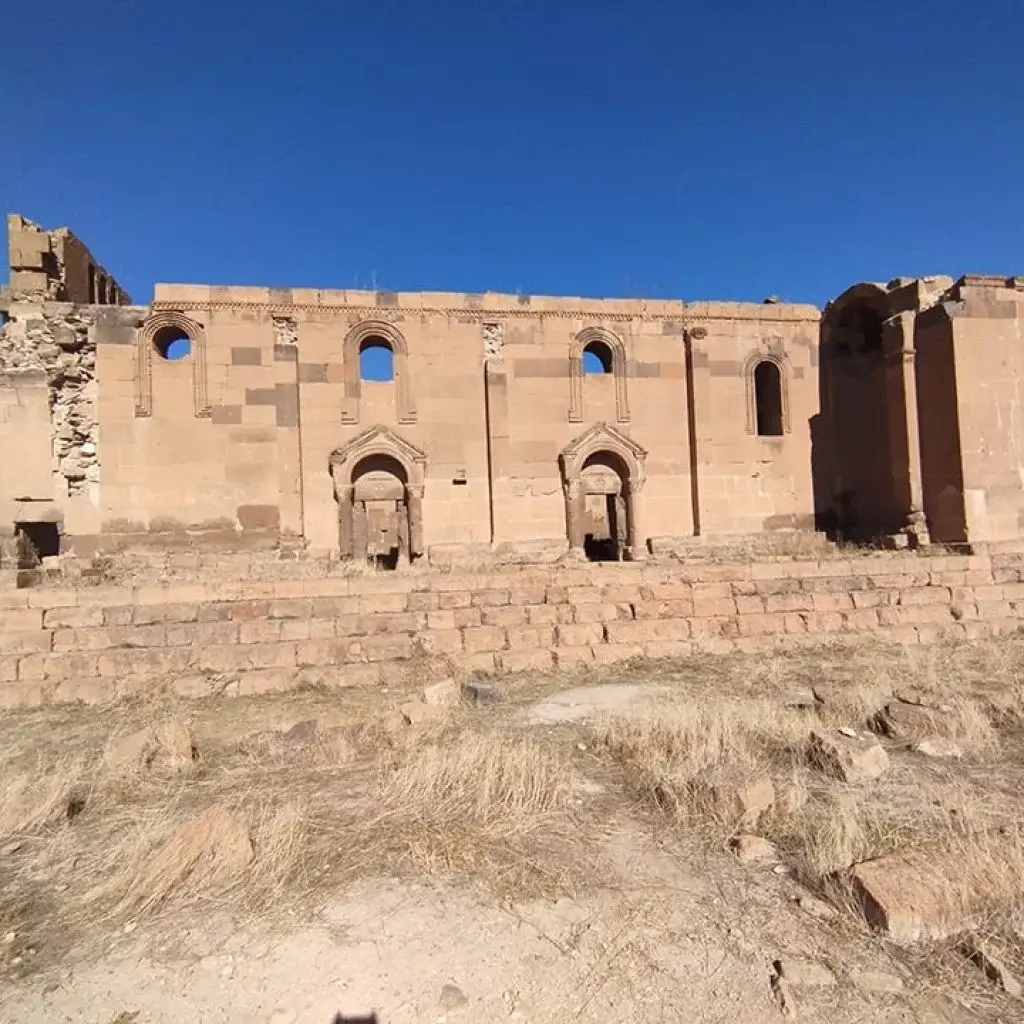
Yereruyk is a three-nave basilica with thick lateral walls — one of the largest Armenian churches of its period. The roof was originally carried on wooden trusses; today only the stone walls and arches remain. The nave was separated from the side aisles by two pairs of arcades, the central nave terminated in a semicircular apse flanked by two side chapels, and arcaded galleries ran along the north, west and south facades.
What sets the basilica apart from later Armenian churches is its six-step stone stylobate — a stepped platform that lifts the entire building above the surrounding plateau. The same architectural device appears at Tekor (late 5th century) and at Zvartnots (7th century), but in the broader history of Armenian church architecture it is rare; some scholars have argued that such a high stepped base hints at an earlier pagan temple on the same site, although there is no direct evidence.
Several features show the close connection with early Christian Syria:
- The high angular towers projecting on the west facade are characteristic of contemporary Syrian basilicas.
- A decorative band on the windows follows Syrian models.
- The Maltese Cross with four equal arms, sometimes enclosed in a medallion and accompanied by animals or trees, recurs across the sculptural decoration in a pattern repeatedly seen in Syrian Christian art.
- At the east end of the south facade runs a Greek inscription that closely parallels the inscription at the late-5th-century Syrian monastery of Deir Sem’an (Qal’at Sem’an) — direct material evidence of the cultural exchange between the two Christian heartlands.
The thick walls have survived two earthquakes that destroyed lesser buildings nearby — a damaging tremor in 1679 and the catastrophic 1988 Spitak earthquake, both of which Yereruyk weathered. The roof, however, was lost long ago, and the building stands open to the sky.
The name “Yereruyk”
The Armenian verb yereral (երերալ) means “to quiver” or “to sway.” Local tradition explains the basilica’s name by saying that the church, raised high on its stepped stylobate and on its arcaded galleries, looked from a distance as if it were shaking — as if the columns supporting the roof were trembling in the heat haze of the Shirak plateau. The poetic name has stuck through 1,500 years
The view of Ani across the river
For most visitors the strongest impression of Yereruyk is not the basilica itself but the landscape it stands in. The plateau drops down to the Akhurian river gorge, which marks the present-day border between Armenia and Turkey, and on the opposite cliff — five kilometres away in a straight line — sit the ruins of Ani, the 10th–11th-century capital of the Armenian Bagratid kingdom, once one of the largest cities in the medieval world. The border cannot be crossed at this point, but Ani’s massive defensive walls, its towers and the silhouettes of its surviving cathedrals are clearly visible against the western sky.
Standing on the stylobate of Yereruyk and looking at Ani in the distance is one of the more affecting experiences a traveller can have in Armenia: two of the earliest and grandest Armenian Christian sites face each other across a closed border.
How to get to Yereruyk Basilica
From Yerevan it is 130 km via Gyumri — about 2 hours by car. From Gyumri the basilica is a further 45 km, roughly 40 minutes on a paved road, with the final 2 km on a packed-dirt track that any ordinary passenger car can handle in dry weather. There is no public transport to the site; from Gyumri the only options are a hired car, a taxi, or a car with driver from Yerevan covering a full Shirak day.
A natural Shirak loop for a single day is Yerevan → Aritchavank → Gyumri → Yereruyk Basilica → Trchkan Waterfall → Yerevan (or the same circuit in reverse). Each stop sits comfortably within a 30–60-minute drive of the next.
Practical tips on site
- The basilica sits on an open, unfenced plateau with no ticket office, no opening hours, no infrastructure — and almost no other visitors. Plan accordingly: bring water, food and a windbreaker, and wear sturdy walking shoes because the ground around the ruins is uneven and stony.
- A small information panel stands near the entrance.
- The wind on the plateau can be sharp even in summer; the temperature in the open ruins is often noticeably cooler than in Gyumri.
- Plan 30–45 minutes on site. With a walk to look down into the Akhurian gorge, allow up to an hour.
- For the best view across to Ani, walk a short way north along the plateau in the direction of the village of Haykadzor; the village is the standard local viewpoint.
- Yereruyk is one of the least-visited sites of its rank in Armenia — for travellers tired of large groups at Geghard or Tatev, it is a welcome contrast.
What to see nearby
- Gyumri (~45 km) — Armenia’s second city, with the historic Kumayri district of black-tuff 19th-century architecture, the old Russian quarter, and a series of museums.
- Aritchavank Monastery (~60 km) — a 7th–13th-century monastic complex with the Zakarian cathedral and an unusual 20-faceted dome.
- Trchkan Waterfall (~80 km, on the Shirak / Lori border) — Armenia’s tallest year-round waterfall, often combined with Yereruyk and Gyumri on a single-day route.
- Marmashen Monastery (~50 km) — a 10th-century monastic complex on the Akhurian river, with its own claim to Bagratid heritage.
- Amberd Fortress (~90 km on the return route to Yerevan) — a 10th–13th-century fortress on the south slope of Mount Aragats.
- The view of Ani — from the village of Haykadzor a few kilometres north, the silhouette of the medieval city is visible across the gorge.
Frequently asked questions
Yereruyk is one of the least-visited and most affecting sites in Armenia: a 4th-century basilica that stands roofless on a quiet plateau in Shirak, with another 11th-century Armenian capital — Ani — visible across a closed border, and the wind of the Anatolian highlands moving through arched openings that were carved by builders working in dialogue with Syria. The easiest way to reach it from the capital is on a one-day Shirak route with a private car and driver from Yerevan.


