Mount Ararat

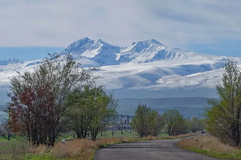
Mount Ararat is the great twin-peaked volcano that rises over the Ararat plain and the most enduring symbol in Armenian visual culture. Two clearly separated summits — Greater Ararat (Մասիս / Masis, 5,137 m) and Lesser Ararat (Սիս / Sis, 3,896 m) — appear on the southern horizon from Yerevan on any clear day, and on the country’s coat of arms in every government office. The mountain sits in eastern Turkey, just across the Armenian border; from Armenia, it is the view that matters. This page is a guide to the best places to see it, the times of day and year when the view is at its clearest, and how to photograph it.
Quick Facts
- Location: Turkey
- Also known as: Masis, Greater Ararat, Mount Masis, Արարատ, Մասիս
- Elevation: 5,137 m
About the mountain
Ararat is a dormant compound stratovolcano with two peaks separated by a high saddle. Greater Ararat is the higher of the two summits at 5,137 metres above sea level — one of the highest mountains in the wider region and the only peak in the Armenian Highlands that holds permanent snow. Lesser Ararat stands about 12 km to the south-east at 3,896 metres, a smaller, sharper cone that, in clear weather, mirrors the larger summit and gives the mountain its unmistakable double-peaked silhouette. The last recorded eruption was in 1840.
The mountain massif lies in Iğdır Province in eastern Turkey, immediately across the Armenian border; the standard climb runs from the town of Doğubayazıt on the Turkish side. From Armenia the mountain cannot be approached on foot, but the flat, fertile Ararat plain between Yerevan and the border means the view from the Armenian side is one of the longest, cleanest mountain views in the South Caucasus — nothing higher than vineyards stands between the city and the peak.
Both peaks carry Armenian names: Masis for Greater Ararat and Sis for Lesser Ararat. In Armenian tradition, Masis is the older and more common name for the mountain as a whole.
Mount Ararat in Armenian culture
Ararat is the defining visual emblem of Armenia. It is the centrepiece of the national coat of arms, the name of the country’s most famous brandy, the name of its football club, the title of countless paintings — and the reason Armenian poets and photographers keep returning to the same southern horizon over Yerevan.
The cultural weight of the mountain in Armenia is grounded in two long traditions. The Biblical tradition identifies “the mountains of Ararat” as the place where Noah’s Ark came to rest after the Flood (Genesis 8:4); the connection of this passage to the present-day Mount Ararat has been part of Armenian sacred geography for more than fifteen hundred years. The religious tradition ties Ararat to the founding story of the Armenian Apostolic Church: the king who accepted Christianity as the state religion of Armenia in 301 AD — making it the first Christian state in the world — was converted by Saint Gregory the Illuminator, who had been imprisoned in a pit at what is now the monastery of Khor Virap, directly at the foot of the mountain on the Armenian side.
For most visitors today, the mountain is experienced as a view: a presence on the southern horizon of every clear morning in Yerevan, and a backdrop to almost every photograph taken in the Ararat Valley.
Where to see Mount Ararat from Armenia
The view from Armenia is best at four kinds of places: from the monastery directly at the foot of the mountain, from a small historic viewpoint on the way to Garni, from the hills and fields just south of Yerevan, and from a handful of city viewpoints when the air is clear.
Khor Virap
The classic Armenian view. Khor Virap is a 17th-century monastic complex 45 km south of Yerevan, sitting on a small hill on the Ararat plain about 100 metres from the Turkish border. The mountain rises directly behind it — there is nothing between the monastery and the peak — and the combination of foreground (the monastery walls, the vineyards, the distant border fence) and background (the full bulk of Mount Ararat) is the single most photographed scene in Armenia.
- Distance from Yerevan: about 45 km
- Drive time: 50–70 minutes
- Best time: sunrise (cleanest air, soft light, almost no other visitors); a second window in the hour before sunset
- Where to stand for the postcard: the small dirt road that leads off the main approach into the surrounding fields — most photographers take the well-known shot from there rather than from the monastery courtyard
- Pairs naturally with: a winery visit in the Areni / Vayots Dzor region in the afternoon
This is the destination if you only have time for one Ararat viewpoint. A comfortable visit can be arranged with a private day tour from Yerevan or a car with driver.
Charents Arch
A short, single basalt archway on the road from Yerevan to Garni, built in 1957 in memory of the 20th-century Armenian poet Yeghishe Charents. The arch frames Mount Ararat in a near-perfect compositional rectangle, with the Ararat plain stretching out beneath it. The site is on the way to one of the country’s most-visited day-trip destinations, the Garni Temple and Geghard Monastery, which makes it a near-zero-detour viewpoint.
- Distance from Yerevan: about 25 km
- Drive time: 30–40 minutes
- Best time: morning, when the eastern light is on the mountain
- Pairs naturally with: the Garni–Geghard day-trip line
The Artashat hills and the village of Lusarat
A short detour from the Khor Virap road. The low hills rising south-east of the village of Lusarat lift you a few dozen metres above the Ararat plain — enough to clear the haze that often sits over the valley at midday and to produce uncluttered panoramas without the crowds at Khor Virap. The drive into the hills uses a gravel road; after rain, prefer a higher-clearance vehicle.
- Distance from Yerevan: about 50 km
- Drive time: about an hour
- Best time: late afternoon for the light, mornings for the air clarity
- Pairs naturally with: the Khor Virap stop on the same day
Yerevan city viewpoints
On clear days, Ararat is visible from the city itself. The most reliable spots:
- Cascade Complex — from the upper terraces (especially around the 5th tier and above), the mountain is framed straight down the line of Yerevan’s central boulevard
- Victory Park (Akhtanak Park) and the Mother Armenia monument — the highest publicly accessible viewpoint in Yerevan, particularly clean in winter
- Tsitsernakaberd Memorial Complex — the Genocide Memorial sits on a hill west of the centre with a wide open view to the south
- Republic Square (limited but visible from the centre on rare clear days)
City viewpoints are at their best in winter and after rain, when the cold air pushes the haze out of the valley and the mountain reads sharper than on any summer morning.
When the view is at its clearest
- Winter (December–February). The single best season. Cold, dry air keeps the haze down, the mountain is fully snow-capped, and views from the Cascade, from the highway south of Yerevan and from Khor Virap are at their sharpest.
- Early spring (March–April). Visibility is good, the snow on the mountain is at its peak, and mornings often have the long, low light photographers prefer. Some haze can build up in the afternoons.
- Autumn (October–November). Reliable mornings, low afternoon humidity, and the most consistent sunsets of the year. Often the best month-long window for photography.
- Summer (June–August). The hardest season. Daytime haze can hide the mountain for most of the day. Plan for sunrise or the last hour before sunset; midday views are often poor.
- After weather fronts. For one or two days after a storm or a strong wind, the air over the valley clears completely and the mountain looks as if it has been moved 10 km closer. The best photographs from Yerevan are almost always taken on these days.
Photography tips
- Time: sunrise gives the cleanest air; the last hour before sunset gives the softest light. Avoid midday from May to September.
- Lens choice: a standard 24–70 mm for foreground composition (the monastery, the vineyards, the arch); a 70–200 mm to “compress” the mountain and pull it forward in the frame.
- Composition: use leading lines — road verges, vineyard rows, stone walls, the line of the Khor Virap perimeter wall.
- Weather: cirrus cloud at altitude flatters the upper slopes; a small lenticular “cap” on the summit means strong wind aloft.
- Drones: Khor Virap sits within sight of the international border, and aerial photography in this zone is regulated. Check current rules and posted restrictions before flying; in case of doubt, do not fly here.
A half-day “Mount Ararat in its best light” plan
- Leave Yerevan 90–120 minutes before sunrise.
- Khor Virap at sunrise — 30 to 40 minutes for photography from the fields and the perimeter wall.
- The Lusarat hills for crowd-free wide panoramas with a slight elevation.
- Return to Yerevan via the Charents Arch if the weather is still holding — a clean second viewpoint to close the day.
The same itinerary works as part of a private day tour from Yerevan or with a car with driver for the morning.
Frequently asked questions
Mount Ararat is one of those landmarks that visitors first see and only later understand. The mountain dominates the southern view from every clear morning in Yerevan, sits behind every postcard from the country, and gives Armenia its quietest, longest-running visual signature. Plan one early morning at Khor Virap, leave time for a single quiet stop on the way back, and the mountain will do the rest.