Gegharot Waterfall
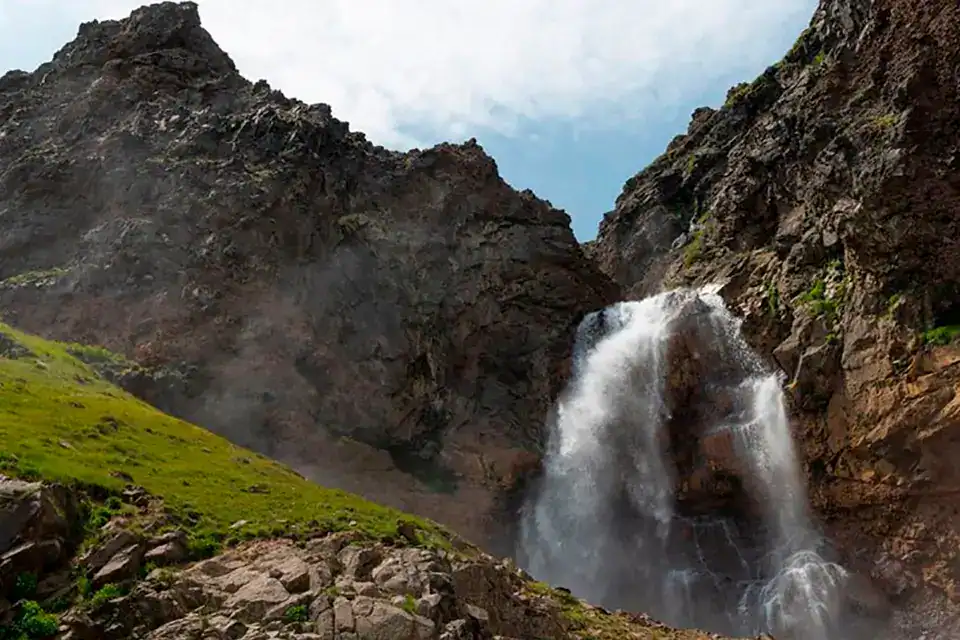
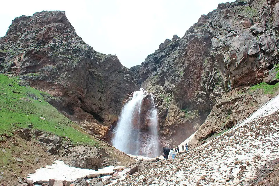
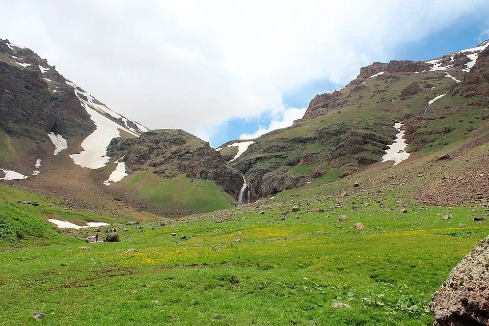
Gegharot Waterfall is the highest‑situated waterfall in Armenia — a 17‑meter cascade tucked into the basalt slopes of Mount Aragats at around 3,000 m above sea level. It sits on the Gegharot River, a tributary of the Kasagh, surrounded by alpine meadows and volcanic rock. In spring the flow is powerful from snowmelt; in summer the water is icy and crystal clear; in winter the cascade freezes completely into a sculpted wall of ice. There is almost no infrastructure on the way — that wildness is exactly why hikers love it. Gegharot also serves as the closest starting point for climbing Mount Aragats’s North Peak (4,090 m), the highest point in Armenia.
Quick Facts
- Location: Aragats village, Aragatsotn Province
- Also known as: Gegharot Waterfall, Gegharot Falls, Գեղարոտի ջրվեժ
- From Yerevan: About 70 km from Yerevan + off-road section
- Height: 17 m
- Elevation: 3000 m
- Entrance fee: Free
- Time needed: Full day
- Best time to visit: June – September
- Status: Natural monument
- GPS coordinates:
40.501931, 44.207750

Key takeaway: go in good weather, start early, check the dirt road condition and the forecast for afternoon thunderstorms.
Why Visit Gegharot Waterfall
Gegharot is one of Armenia’s most photogenic high‑altitude sites. Visually it resembles Trchkan Waterfall — same basalt step, same vertical drop — but the surroundings are completely different: not a forested gorge, but open alpine meadows with a clear‑weather view all the way to Mount Ararat. The water stays icy even in midsummer; it’s reliably 10–15 °C cooler at the falls than in Yerevan.
For trekkers, Gegharot isn’t a final destination but a waypoint. The Gegharot River gorge is the classic approach route to Aragats’s North Peak (4,090 m, the highest point in Armenia). The full trek from Aragats village past the waterfall to the crater rim is about 14 km one way.
The slopes of Aragats are home to brown bears, though sightings are rare. Don’t leave food unattended, hike in a group, and make noise on quieter sections of the trail.
When to Visit
- June – September: the optimal window. Snow has melted off the trail, the path is dry, days are long.
- May – early June: maximum flow from snowmelt, but slush, wet rock and stream crossings make the approach harder.
- October: cool and windy, daylight shrinking, first frosts possible.
- Winter / early spring: access depends on snow conditions and requires real mountain skills. Not recommended without experience and gear.
How to Get to Gegharot from Yerevan
- By car (≈ 2–2.5 hours to the trailhead): Take the M1 highway toward Aparan, turn off toward Aragats village and the pasture road at the foot of the mountain, then continue on a dirt road to where the walking section starts. The final kilometres are rough, with ruts and puddles after rain. Vehicle: high clearance recommended, 4×4 strongly preferred.
- Driver / day tour: if you’d rather not drive the off‑road section yourself, a car with driver in Yerevan is the simplest way to do this trip — the driver handles the dirt road and you spend the day hiking instead of navigating.
- Navigation: download offline maps before leaving Yerevan — mobile coverage in the gorge is patchy.
The Trail
There are two common ways to reach the falls, depending on how far up the dirt road you can or want to drive.
Short option (drive close, walk in)
- Distance: 2–6 km round trip, depending on where you park
- Elevation gain: 150–300 m
- Time at the site: 1–2 hours for photos and rest, plus the drive
Most visitors take this version. The path follows the Gegharot River up the gorge; the last stretch climbs along the right bank to a viewing spot above the cascade.
Long option (hike from Aragats village)
- Distance: ~11 km one way from the village
- Starting elevation: ~2,000 m at the village; the waterfall sits at ~3,000 m
- Time: a full day; many hikers continue to the North Peak (another ~6 km from the falls)
- Surface: pasture tracks, rocky sections, grassy slopes; wet stone and spray near the falls
This is the route for hikers who want the full Aragats experience. The trail can be combined with a summit attempt on the North Peak.
Tip: approach from above first for the panoramic view, then drop carefully to the lower viewpoint for the cascade itself — midday spray often produces a rainbow.
Safety and Gear
- Trekking boots with grip; trekking poles if you have them
- Wind‑proof warm jacket — Aragats is exposed and the weather flips fast
- Rain shell and camera covers — there is a constant fine mist near the cascade
- Water, snacks, first‑aid kit, sun protection — at 3,000 m UV is intense even in cloud
- Stay back from wet rock edges and from the lip during high water
- Respect grazing fences; close gates after you — these are working shepherd areas
Brown Bears on the Trail
Worth its own note. The Gegharot gorge has a resident brown bear population. Encounters are rare but possible:
- Hike in a group, not solo
- Make occasional noise on quieter sections — bears avoid people they hear coming
- Never leave food or scented items unattended at rest stops
- If you do see a bear: stay calm, do not run, back away slowly without turning around, give it space
What to Combine With in One Day
Gegharot pairs naturally with the rest of the Aragats region:
- Amberd Fortress and the 11th‑century church on the southern slope of Aragats
- Lake Kari — a high‑altitude lake at 3,200 m, classic alternative starting point for North Peak climbers
- Saghmosavank and Hovhannavank monasteries — two stone monasteries perched on the rim of the Kasagh canyon
- Aparan Reservoir and the village bakeries (lavash, gata)
- Kasagh Gorge — up to 200 m deep, basalt columns and caves, climbing routes
Suggested Day Trip from Yerevan
Yerevan → Aragats village → Gegharot Waterfall → Aparan Reservoir → Yerevan. Start around 07:30, reach the waterfall by midday, picnic lunch on the trail, lake stop on the way back, return to Yerevan in the evening. Lake Kari can swap in for Aparan if you want more altitude.
Photography Tips
- An ND filter (ND64 / ND1000) and a tripod for silky‑water shots
- Morning light is soft and side‑lit; midday spray often produces a rainbow
- Lens hood and a microfiber cloth — spray gets on the front element fast
Good to Know
- No infrastructure at the waterfall: toilets and cafés only in villages along the way
- Pack out all rubbish — the high‑altitude environment is fragile
- In summer, shepherd dogs around grazing herds: walk wide around the herd, don’t run, stay near the shepherd or stay with your group
FAQ
Gegharot is the high‑altitude member of Armenia’s waterfall family — for comparison see our guides to Trchkan Waterfall (the tallest vertical drop, with a similar basalt setting), Jermuk Waterfall, Shaki Waterfall and Herher Waterfall. For the full list of attractions, browse our things to do in Armenia hub.


