

Goris
Goris (Armenian: Գորիս) is a small town in Syunik Province in southern Armenia. It sits in a narrow mountain basin along the Vararakn River — a tributary of the Vorotan — at elevations between 1,250 and 1,520 metres. Around 20,000 people live here on 50 km². Founded in 1870 as the administrative centre of the Zangezur district under Russian rule, Goris received formal city status in 1904. From Yerevan it is 240 km south — a drive of three and a half to four hours across the Vorotan Pass.
Goris is a city that grew out of caves. On the left bank of the Vararakn stands one of the strangest landscapes in Armenia: a stone forest of volcanic tuff — pyramids, columns and towers weathered into shapes that people have lived in for thousands of years. On the right bank sits the town proper — a planned, grid-laid 19th-century town of stone houses and streets meeting at right angles. This contrast, cave and grid, ancient and imperial, gives Goris a character no other Armenian town has. For travellers it is also the gateway to Tatev: twenty kilometres south is the medieval Tatev Monastery and the Wings of Tatev — the longest reversible aerial tramway in the world.
Geography and climate
Goris sits in a deep mountain basin shaped like the hull of a flat-bottomed boat. On both long sides, rocky ridges rise, riddled with caves. The Vararakn River cuts through the middle of the town. The surrounding hills hold marble, limestone and dolomite deposits.
The climate is mountain — milder than the Ararat Plain. July averages +19 °C, January −1 °C. Annual precipitation is around 700 mm, which makes Goris one of the wettest cities in Armenia. Snow falls in winter but the roads are cleared. Summers are comfortable and free of the punishing Yerevan heat.
From caves to district capital: a short history
The Goris area has been inhabited since deep antiquity. The first written reference is Urartian: King Rusa I (8th century BC) lists a country called Gorist among the lands he subdued, in a cuneiform inscription. Bronze ornaments, daggers and pottery from the 3rd and 2nd millennia BC have been found in local excavations.
In the medieval period there was an Old Goris, mentioned by the 13th-century historian Stephanos Orbelian. People lived in caves on the sides of the basin — some of these dwellings were used continuously into the mid-20th century.
In 1813 the area passed to the Russian Empire under the Treaty of Gulistan. In 1870, on the right bank of the river, a new town was laid out as the administrative centre of the Zangezur district. The plan called for 36 streets meeting at right angles, a square with two-storey stone buildings, a town church and a public garden. This European grid, dropped into a Caucasian mountain basin, still defines the shape of modern Goris. The town received formal city status in 1904.
Goris is the birthplace of the writer Aksel Bakunts (1899–1937), one of the major Armenian prose writers of the 20th century, whose short stories about Zangezur life remain classics. He was executed during Stalin’s Great Purge in 1937; his house in Goris is a museum today.
What to see in Goris and around
The Stone Forest and Old Goris
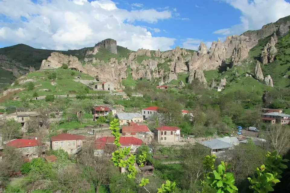
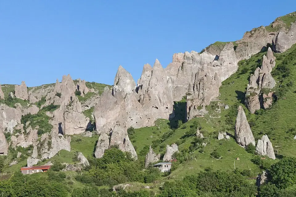
On the left bank of the Vararakn is a natural labyrinth of stone pyramids, columns and towers formed by the weathering of volcanic tuff. In the walls of these rock formations are dozens of caves — natural and enlarged by hand — used as dwellings for thousands of years. Among them stand the remains of medieval churches and chapels, the palaces of the melik princes, a rock amphitheatre, and the citadel of the Dzagadzor fortress. The 17th-century Surb Rhipsime Church is one of the surviving cave-side shrines. Old Goris is essentially an open-air museum, free to walk through.
Khndzoresk cave village
A village 8 km east of Goris — home to an enormous complex of cave dwellings running along the slopes of a 3-kilometre gorge. People lived here until the 1950s. Suspended across the gorge is a 160-metre footbridge, built in 2012, that is one of the most photographed sights in Armenia. On the far side stand a medieval church and paths cut into the cliff face. Full page: Khndzoresk Cave Village.
Tatev Monastery and the Wings of Tatev
Tatev Monastery (9th century) is one of the most historically important monasteries in Armenia. In the 14th and 15th centuries it was home to Tatev University, the leading centre of philosophy, science and manuscript illumination in medieval Armenia. The monastery stands on the edge of a cliff above the deep Vorotan Gorge.
The Wings of Tatev cable car (opened 2010) is the longest reversible aerial tramway in the world: 5,752 metres, up to 320 metres above the gorge floor, journey time 12–15 minutes. A cabin holds 30 people. Round-trip ticket around 7,000 AMD. Runs daily except Monday. The lower station is at Halidzor, 20 km south of Goris.
On the way to Tatev is the Devil’s Bridge — a natural stone arch over the Vorotan River, with mineral springs and caves beneath. Full page: Tatev Monastery.
In the town
The Aksel Bakunts House-Museum — personal effects and manuscripts of the writer. The Goris Local History Museum — archaeology, ethnography and history of Syunik. The Seven Springs monument — a landscape composition around natural spring water. Surb Grigor Lusavorich Cathedral — closed during the Soviet era and used as a geological museum and grain store; reopened for worship in 1989. The Melik House (18th century) — an example of Zangezur palace architecture. The Zangezur sculptural composition at the entrance to town — a viewpoint over the whole basin.
Who Goris suits
Travellers heading south to Tatev — Goris is the natural base. A day trip from Yerevan is technically possible but exhausting (8+ hours in the car). Sleeping in Goris turns the same trip into a comfortable two days.
Anyone interested in archaeology and cave dwellings — Old Goris, Khndzoresk and, 30 km further at Sisian, Karahunj give this small area of Syunik the highest density of pre-Christian sites in Armenia.
Photographers — the Khndzoresk suspension bridge, the view of Tatev from the cable car, and the stone pyramids of Old Goris at sunset are among Armenia’s most-shot landscapes.
Travellers who want the “real” Armenia — Goris is a long way from the tourist crowds of the first day out of Yerevan. It is quieter, plainer, and more honest.
Best time to visit
Spring (April–May) — green slopes and full waterfalls. The Vorotan Pass may still be chilly.
Summer (June–August) — the best time. Comfortable +19 to +25 °C, no Yerevan heat, all roads and trails open.
Autumn (September–October) — gold and copper colours, clear air, few tourists. The best time for photography.
Winter — snowy and quiet. The Wings of Tatev cable car still runs, at lower prices. Some unpaved roads to Devil’s Bridge may be difficult.
Combine with nearby places
Khndzoresk cave village — 8 km east, the suspension bridge and cave dwellings.
Tatev Monastery — 20 km south, with the world-record cable car.
Karahunj (Zorats Karer) — 30 km north, the “Armenian Stonehenge” near Sisian.
Shaki Waterfall — near Sisian, on the road back.
Sisian — 50 km north, the neighbouring town.
The classic Syunik loop from Yerevan (two days): Yerevan → Noravank → Areni (wine) → Goris (overnight) → Tatev → Khndzoresk → Yerevan. Easiest with a car with driver from Yerevan or a private day tour.
How to get there
Goris is 240 km from Yerevan on the M-2 highway — 3.5 to 4 hours by car via Areni and the Vorotan Pass. The road is asphalted throughout; the pass is a proper mountain switchback with views.
Marshrutkas run from Yerevan’s Southern Bus Station once or twice a day, cost around 3,000 AMD, and take 4–5 hours. For visits to Tatev, Khndzoresk and Karahunj a vehicle is required from Goris.
Because the drive is long, a same-day Yerevan–Tatev–Yerevan trip works but eats eight or more hours on the road. The cleanest way is a two-day loop with a night in Goris.
Frequently Asked Questions
See more on Armenia’s cities or plan the trip with a car with driver from Yerevan.