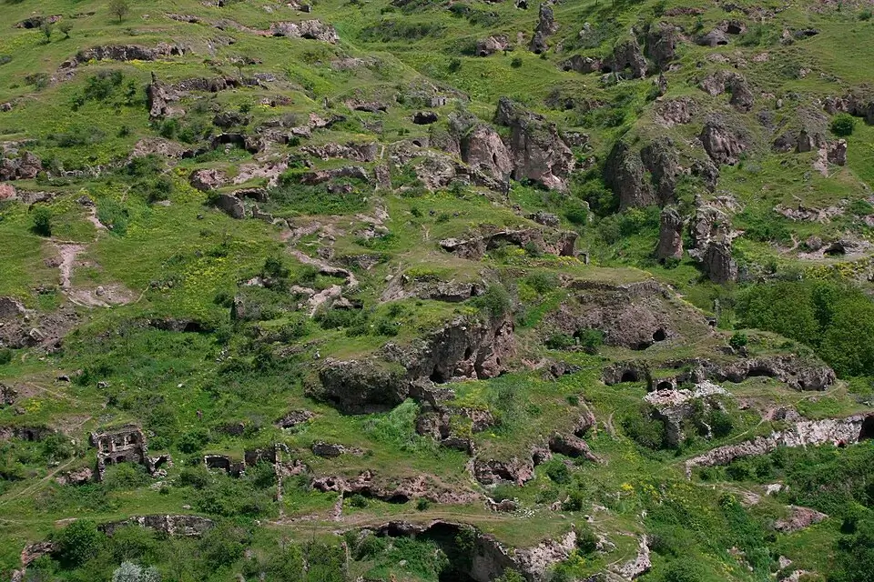
Khndzoresk Cave Village (Old Khndzoresk)

People still lived here 70 years ago. Not in deep antiquity — in the middle of the 20th century. Khndzoresk (Armenian Խնձորեսկ) is a cave village on the steep slopes of a 3-kilometre gorge in Armenia’s Syunik Province, and one of the strangest landscapes in the country. About 3,000 caves are dug into the cliffs — once homes, workshops, schools and churches. At its peak the village held 8,300 people, making it one of the largest settlements in all of eastern Armenia. The Soviet authorities resettled the residents in the 1950s, and the last inhabitant left in 1958. Today Old Khndzoresk is an open-air museum: rock-cut houses, two surviving 17th-century churches, the tomb of the national hero Mkhitar Sparapet, and a 160-metre swinging suspension bridge that hangs 63 metres above the canyon floor.
Quick Facts
- Built / Founded: First written record 13th century; abandoned 1958
- Location: 8 km east of Goris, Khndzoresk community, Syunik Province
- Also known as: Old Khndzoresk, Khndzoresk Cave Village, Khor Dzor, Խնձորեսկ
- From Yerevan: 250 km / 3.5–4 hours
- Elevation: 1580 m
- Entrance fee: 1,500 AMD per person
- Time needed: 1.5–2.5 hours on site; pairs with Tatev on a Syunik loop
- Best time to visit: May–October; morning or sunset for photography
- Status: Historical monument
- GPS coordinates:
39.4998425,46.4309082
What You’re Looking At
The gorge stretches about three kilometres along the slopes east of the modern village (called New Khndzoresk, built in the 1950s on top of the canyon). The cliffs are pocked with cave dwellings stacked one above another for 20 to 30 metres of vertical height — so densely arranged that the roof of one house used to serve as the courtyard of the one above it. From a distance it looks like a single enormous multi-storey building. Add a 525-foot swinging bridge over the central drop, a 17th-century hermitage on a spur halfway down, and a few stone-rimmed springs at the bottom, and you have what’s probably the most cinematic single site in Syunik.
In 2016 National Geographic put Armenia on its list of “10 places that deserve more travellers”, and Old Khndzoresk was specifically called out among the country’s must-see destinations. That’s the level of recognition this site has, even though most foreign visitors miss it.
A Note on the Name
The Armenian word khndzor means “apple”, and one tradition says the village took its name from the wild apple trees that once grew here in great numbers. A second tradition is more geographical: the original name was Khor Dzor — “Deep Gorge” — and over centuries it softened into “Khndzoresk”. Both etymologies are plausible — the canyon is genuinely deep, and the apple trees are still there.
You’ll see the site labelled in different ways depending on the source: Old Khndzoresk (in contrast to the modern village above the canyon), Khndzoresk Cave Village, simply Khndzoresk, or occasionally Khor Dzor. All refer to the same gorge.
A History From the 13th Century to 1958
The first surviving written record of Khndzoresk dates to the 13th century, when the village appears in the tax registers of Tatev Monastery — Khndzoresk owed the monastery 10 drams. The Syunik historian Stepanos Orbelyan also mentions the settlement. Archaeologists believe the gorge was inhabited for much longer than that — possibly more than a thousand years before the first records.
Local folk history traces the founding to two brothers — Janaghan and Tavari — who fled a Persian massacre, hid in the forests of Syunik, and stumbled into the gorge years later while chasing a deer. Whatever the truth of the story, the brothers chose well: the gorge is so steep and so isolated that, by local tradition, Khndzoresk is the only Armenian village never captured by an invading army.
In 1735 the Catholicos of all Armenians, Abraham Kretatsi, visited Khndzoresk and left the most detailed description we have from the period. He recorded that the cave houses, perched 20 to 30 metres up the cliff, served not only as dwellings but as fortifications — residents climbed up to them by rope, drew the ropes in, and the village was effectively unreachable.
The eighteenth century is what made Khndzoresk famous in Armenian history. The village was a base of the liberation movement of David Bek — the 1722–1730 Armenian uprising against Persian rule — and its fortress served as Mkhitar Sparapet’s military headquarters from 1728 to 1730 (more on him below).
By 1913 Khndzoresk had 1,800 households, 7 schools, 27 shops, dyeworks, tanneries and a peak population of about 8,300 people. It was the largest village in eastern Armenia.
The end came in stages. There are two competing accounts of why the cave village was finally abandoned. One holds that a major earthquake in the 1930s damaged the cliff-side dwellings and made them unsafe, beginning a slow exodus. The other is that Soviet authorities in the 1950s deemed the cave dwellings “uncivilised” and pressured residents to move into a planned village on top of the canyon — partly recycling the old stones as construction material. Both accounts are widely cited, both are partly true, and the result was the same: the last inhabitant left Old Khndzoresk in 1958.
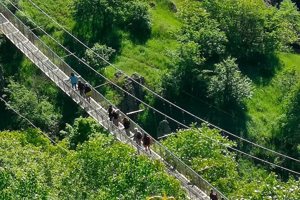
The Suspension Bridge
For half a century after the resettlement, getting from New Khndzoresk to the abandoned village below meant a six-kilometre walk down one side of the gorge and back up the other. That changed in June 2012, when a 160-metre swinging suspension bridge was opened across the canyon — built almost entirely by hand, by the villagers themselves, with funding from a local-born businessman named Zhora Aleksanyan who dedicated the structure to the memory of his parents.
The bridge is sometimes called the “Tibetan Bridge” in English-language tourism. It runs 160 metres end to end, sits 63 metres above the floor of the gorge, is 1.5 metres wide, and is rated for up to 700 people simultaneously. Machinery couldn’t reach the canyon, so the concrete segments and steel cables were carried in on horseback. It connects two historic districts of Old Khndzoresk — Ghandunts nov and Nerkin Tagh — and is now the standard entry point to the site.
The bridge sways visibly with every footstep. That’s by design; it’s perfectly safe. If you have a real fear of heights, you can also reach the cave village by the older walking path on the New Khndzoresk side.
How People Actually Lived in the Caves
There were two kinds of dwellings on the slopes. The lower caves were proper houses — often with arched entrances, several rooms, two tonir clay ovens (one for baking lavash, one for cooking the evening meal, also heating the home through the night), and stone-walled extensions that connected them to neighbouring dwellings.
The upper caves, called kratakner, were perched 20 to 30 metres up the cliffs and served as refuges in time of war. They were reached by ropes and ladders that could be pulled up; with the ropes drawn in, the caves were essentially unreachable. Local historians point to Khndzoresk as one of the places where the distinctively Armenian round arch first developed in residential architecture.
Near one end of the bridge there’s a reconstructed four-room cave dwelling — a full demonstration of how an upper-middle-class Khndzoresk family actually lived. Walking through it is the single best way to understand the architecture.
Mkhitar Sparapet — The Soldier Killed by His Own Village
Of all the figures connected to Khndzoresk, the one whose grave you’ll visit is Mkhitar Sparapet (c. 1690–1730) — a military commander of the early-18th-century Armenian liberation movement led by David Bek. After David Bek’s death in 1728, Sparapet became the most senior commander still in the field, fighting first the Persians and then the Ottomans for two more years from his base in the Khndzoresk fortress.
The end was tragic. According to the most widely told local tradition, in 1730 Sparapet took refuge in Khndzoresk while fleeing an Ottoman force, and the villagers killed him themselves — fearing that the Ottomans would destroy the village if they discovered him hiding there. Other accounts simply say he died near the village in obscure circumstances. Either way, his stone tomb is in the Anapat hermitage — a small 17th-century scriptorium and monastery on a spur halfway down the gorge, slightly south of the main cave village. It’s a quiet spot, signposted from the bridge, and it’s where most thoughtful visitors spend a few minutes before climbing back up.
The Churches and the Hermitage
Four churches were built in Khndzoresk over the centuries. Two of them are still standing today.
St. Hripsime Church (1663–1666, sources disagree on the exact year) — a three-nave basilica at the bottom of the gorge, the largest and best-preserved church of Old Khndzoresk. Lime-washed walls, an external arcade, and a small belfry.
St. Tadevos (Thaddeus) Church (17th–18th century) — smaller, with an earthen floor and a turf-covered roof, an unusual local style.
Anapat Hermitage (17th century) — a former manuscript-copying centre on a rocky spur on the right side of the gorge. Now partly ruined. The tomb of Mkhitar Sparapet is in its courtyard.
A cave church dating possibly to the 9th–10th centuries — at the south-eastern end of the gorge — is the oldest religious structure of the complex, though only fragmentary.
The Nine Children Spring
One of the springs at the bottom of the gorge has a name and a story. It’s called Inn Manuk — “Nine Children”.
Local tradition holds that during one of the village’s many sieges, the women and girls of Khndzoresk fought alongside the men. A widow named Sona, mother of nine, was killed in the fighting. Her father, the master mason Ohan, built an arched stone fountain at the spot where a spring flowed out near a giant walnut tree, and as he completed it he prayed: “Sacred spring, let your water turn to milk and protect my nine orphaned grandchildren.” The basin of the fountain was carved in the shape of a woman’s breast — visitors today still drink from it by lying down on their hands.
How to Get to Khndzoresk
By car or with a driver from Yerevan — about 250 km, 3.5 to 4 hours on the M-2 highway south past Sisian and Goris. The site is 8 km east of Goris, signposted from the main road. There’s free parking at the cliff-top viewing platform where the bridge starts.
For most travellers the most practical option is a car with driver from Yerevan on the standard Syunik route, combining Khndzoresk with Tatev Monastery, the Wings of Tatev cable car, and ideally Zorats Karer (Carahunge) over a long day or, more comfortably, two days with an overnight in Goris. For larger groups, a minivan with driver handles the same loop. A guided day tour from Yerevan keeps the logistics off your hands.
By marshrutka — Yerevan to Goris (about 4 to 4.5 hours from Kilikia bus station). From Goris, a taxi to the Khndzoresk viewing platform costs roughly 2,000 AMD and takes 15 minutes. There is no direct public transport to the site itself.
When to Visit
May to October is the realistic season. In summer the gorge is noticeably cooler than the surrounding plateau because of the shade and the wind funnelling through, which makes Khndzoresk one of the more comfortable Syunik stops in July and August. Spring and autumn add wildflowers and gold light respectively, with very few other visitors.
Best light for photography is the first hour after sunrise (the eastern slope catches it directly) or the hour before sunset.
Winter is doable but slippery. The path down to the bridge, the bridge itself in frost, and the unmarked trails through the cave village can all be dangerous in snow or after rain. Stay home or bring serious boots.
What to See Nearby
- Goris (8 km) — the “city of stone pyramids”, with a striking historic centre, good restaurants and the most pleasant overnight stop on a Syunik trip. It’s also where the famous cone-shaped rock formations behind the town are easiest to see.
- Tatev Monastery (~30 km) and the Wings of Tatev cable car — the longest reversible aerial tramway in the world. The single biggest attraction in southern Armenia and the natural second half of a Syunik trip.
- Zorats Karer (Carahunge) (~50 km) — the megalithic stone field sometimes called the “Armenian Stonehenge”, on the road from Yerevan.
- Shaki Waterfall (~70 km) — one of the most photogenic waterfalls in southern Armenia, also on the road in.
- Devil’s Bridge (Satani Kamurj) (~40 km) — a natural stone arch over hot springs on the road between Goris and Tatev.
The standard two-day Syunik loop from Yerevan: Day 1 — Zorats Karer + Shaki Waterfall + overnight Goris. Day 2 — Khndzoresk in the morning, Tatev with the cable car in the afternoon, return to Yerevan.
Practical Notes
- Entry fee: 1,500 AMD per person. Payment is usually collected near the entrance or parking/viewpoint area during staffed hours.
- Time on site: 1.5 to 2.5 hours is normal — bridge, cave village, Anapat hermitage, churches, springs at the bottom.
- Bridge and trails: the bridge sways, which is fine. The trails through the cave village are unmade, stony, and in places narrow without railings. Closed shoes with good grip are essential.
- Vertigo: if you have a real fear of heights, the bridge is not the only access point — the walking path down from New Khndzoresk reaches the same gorge.
- Facilities: small cafés and souvenir stalls at the cliff-top viewing platform near the bridge. A toilet is there. Inside the gorge — nothing.
- Phone signal: variable. Download an offline map (maps.me or OsmAnd) before arriving.
- Children: fine on the bridge with adult supervision. More care needed in the cave village itself — many of the trails have unguarded drops.


