Zorats Karer

Zorats Karer — also written Carahunge, Karahunj or Qarahunj — is a prehistoric site of 223 standing basalt stones on a 1,770-metre plateau three kilometres north of the town of Sisian, in Armenia’s Syunik Province. It’s almost always introduced as the “Armenian Stonehenge”, partly because of the shape and partly because some of the stones famously have small drilled holes that some researchers have read as astronomical sights. The truth is more interesting than the marketing line: the site is a major archaeological monument with at least two serious, competing interpretations, and which one is right is still genuinely an open question. This guide walks through what you actually see, what’s been proposed, and what the most recent peer-reviewed work has found.
Quick Facts
- Built / Founded: Estimates 3000–7500 years old (disputed)
- Location: 3 km north of Sisian, Syunik Province
- Also known as: Carahunge, Karahunj, Qarahunj, Armenian Stonehenge, Speaking Stones, Army Stones, Քարահունջ, Զորաց Քարեր
- From Yerevan: 200 km / 3–3.5 hours
- Elevation: 1770 m
- Entrance fee: 1500 AMD
- Time needed: 1–2 hours on site; pairs with Tatev / Khndzoresk on a Syunik loop
- Best time to visit: May–October; September best; sunset for photography
- Status: State Historical-Cultural Preserve (since 2009)
- GPS coordinates:
39.5514, 46.0286
A Note on the Names
The same site appears in guidebooks and maps under several names — they all refer to the same place.
Zorats Karer (Armenian Զորաց Քարեր) is the older folk name, meaning “Army Stones” or “Warrior Stones” — from a tradition that military commanders are buried under some of the slabs.
Carahunge / Karahunj / Qarahunj (Armenian Քարահունջ) is the more recent name, popularised by researchers since the 1980s. It means “Speaking Stones” or “Singing Stones” — from kar (stone) and hunj (sound). The Armenian historian Stepanos Orbelian, writing in the 13th century, already mentions a nearby village called Karundzh in his History of Syunik, so the name is genuinely old.
In 2004, the Armenian parliament formally renamed the monument “Karahunj (Carahunge) Observatory” (Government Decision No. 1095-n) — a political endorsement of one interpretation that the archaeological community has not entirely accepted.
We use “Zorats Karer” throughout this guide because it’s still the most-searched form internationally, but the names are interchangeable.
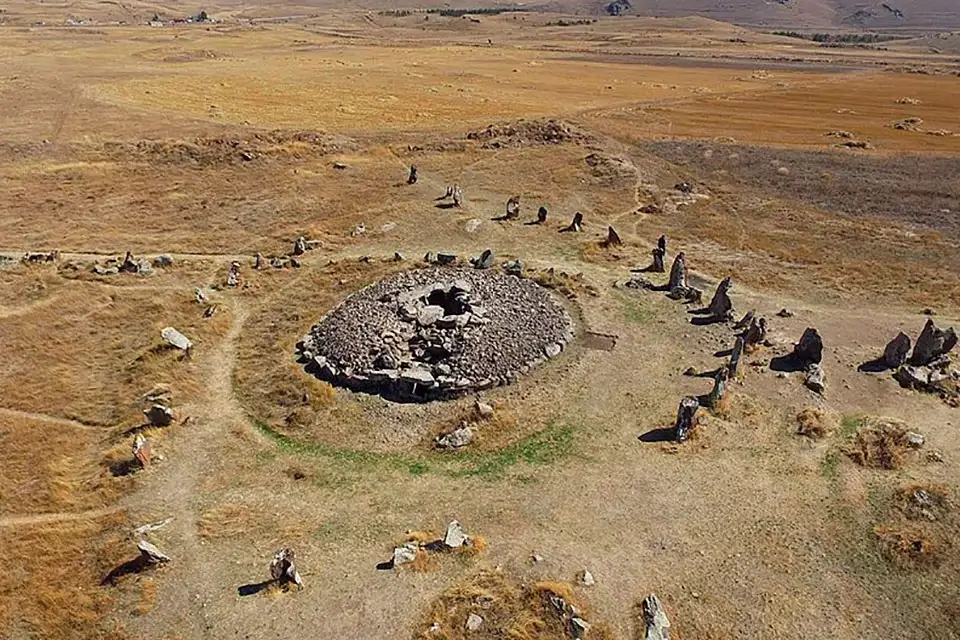
What You Actually See on Site
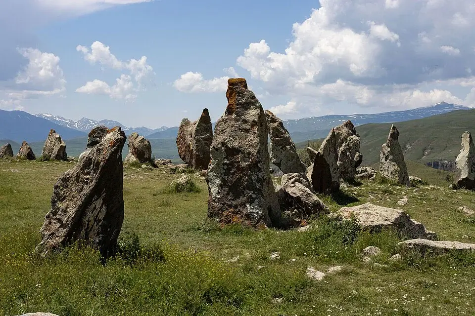
The complex covers a little over seven hectares of an open windswept plateau. The basalt stones — 1.5 to 3 metres tall, weighing up to 10 tonnes — are not randomly scattered. They form a clearly designed structure.
The central ellipse is built from about 40 stones laid out in a long oval. None of the stones in the central ring have holes. Inside the oval are the partial remains of a structure that may have been a temple or burial monument.
A north arm of roughly 80 stones extends about 140 metres north of the centre, and a south arm of roughly 70 stones extends a similar distance south before bending toward the south-west. A short north-eastern alley points away from the central ring toward a horizon point that some researchers connect to summer-solstice sunrise.
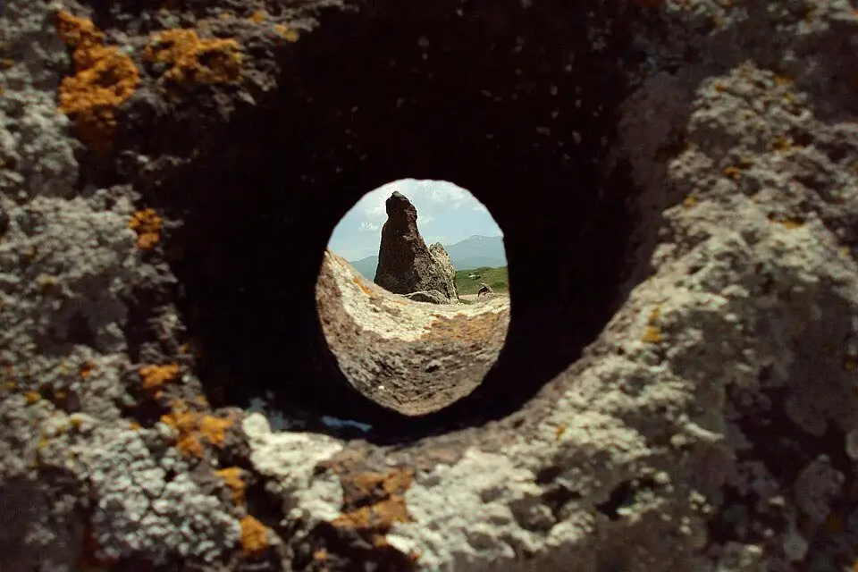
Thirty-seven of the stones have small holes drilled clean through them — 47 holes in total, 4 to 7 centimetres in diameter, mostly on the stones in the north and south arms (not in the central ring). These holes are the defining feature of Zorats Karer and the basis for the entire observatory hypothesis.
A central kurgan (burial mound) inside the complex was excavated during the 20th century and yielded a tomb with swords, fragments of horse harness and pottery, consistent with the burial of an elite warrior.
How Old Is It?
This is where the disagreements begin. The published age range is wide.
The maximalist popular figures, associated with the work of Paris Herouni in the late 1990s, place the site at 7,500 years old or more, which would make it older than Stonehenge by several millennia.
The 2000 archaeological survey by the Institute of Near Eastern Archaeology at LMU Munich, led by Stephan Kroll, dated the monumental burials to the Middle Bronze Age (c. 2000–1500 BCE) through the Iron Age, with a possible Hellenistic phase (c. 300 BCE – 300 CE) when parts of the site may have served as a defensive refuge. By this reading the site is more like 3,000–4,000 years old in its current form.
Both figures are widely cited in different sources. The honest answer is that no comprehensive carbon-dated stratigraphic study has settled the matter, and any dating you read in guides depends on which research tradition that source draws from.
Was It an Observatory? — A Closer Look
The astronomical interpretation is the famous one, and it deserves an honest summary rather than the breathless version most websites give.
The hypothesis was first proposed by archaeologist Onik Khnkikyan after his 1984 rediscovery of the site, then developed by astrophysicist Elma Parsamyan of the Byurakan Observatory (1985), and most prominently by radiophysicist Paris Herouni through six field expeditions between 1994 and 2001. Herouni argued that the holes in the stones were astronomical sights aligned to solstices, equinoxes and the phases of the Moon, and that the site is “one of the world’s oldest astronomical observatories”. The American archaeo-astronomer Gerald Hawkins, famous for his earlier work on Stonehenge, corresponded with Herouni and was broadly sympathetic.
The academic critique has been quietly but firmly the other way. The Munich 2000 survey identified the rows of stones not as astronomical instruments but as the remains of a rubble-and-loam wall in which the upright stones were structural reinforcements — i.e. a city or refuge wall, not an observatory. Archaeo-astronomer Clive Ruggles, one of the field’s leading authorities, has written that the claims for the site’s astronomical significance are “more speculative and less supportable” than is usually presented, adding that direct comparisons with Stonehenge are “less than helpful” — partly because most archaeologists no longer regard Stonehenge itself as a working observatory.
The most pointed critique came from a 2013–2014 peer-reviewed paper by A. César González-García, “Carahunge – A Critical Assessment”. González-García pointed out that for the holes in the megaliths to function as precise solstice sights, a narrow tube would have needed to be inserted into each hole to restrict the field of vision enough — and no such tubes have ever been found. Without them, the holes are too wide to be useful for the kind of astronomical observations Herouni proposed. His conclusion: the archaeo-astronomical claims for the site, as currently argued, are “untenable”, though the question is still open enough to deserve further work.
A reasonable lay summary is: the site clearly meant something to the people who built it, parts of the layout do align with sunrise points, and astronomy may have played some role — but the strong claim of “the world’s oldest observatory” goes beyond what the archaeological evidence currently supports.
What Archaeologists Did Find — The Munich Survey
The 2000 Munich expedition, the most recent systematic archaeological survey of the site, identified Zorats Karer primarily as a necropolis — a burial ground in use from the Middle Bronze Age through the Iron Age, with enormous stone tombs from those periods inside the area. They also concluded that portions of the standing-stone alignments are best explained as the collapsed remains of a defensive wall of rubble and packed loam, with the uprights as reinforcements, possibly built or rebuilt in the Hellenistic to early Roman period as a refuge in times of war.
This is a less romantic interpretation than the observatory story, but it’s the one that currently has the strongest archaeological footing.
The “Armenian Stonehenge” Question
The Stonehenge comparison is unavoidable in any English-language coverage, and it’s both useful and misleading.
It’s useful in the sense that both sites are large prehistoric stone monuments laid out with deliberate geometry, both have elements that point toward solstice sunrise, and visiting one will give you some intuition for the other.
It’s misleading because the two sites are structurally very different. Stonehenge is a precisely engineered ring of dressed sarsens and bluestones erected in the 3rd millennium BCE. Zorats Karer is a much larger open layout of mostly undressed basalt stones whose central ring is an ellipse and whose arms extend hundreds of metres in two directions. And, importantly, the drilled holes in the Zorats Karer stones are a feature with no real analogue at Stonehenge or any other European megalithic site — which makes Zorats Karer genuinely unusual, regardless of what the holes were for.
If you want the short version: it isn’t a copy of Stonehenge, it isn’t really a competitor to Stonehenge, and the marketing label undersells how strange and specific Zorats Karer actually is on its own terms.
How to Get to Zorats Karer
By car or with a driver from Yerevan — about 200 km, 3 to 3.5 hours, on the M-2 highway south past Goris and toward Sisian. The site is 3 km north of Sisian, signposted from the main road. The final approach is on a short gravel track that any car can handle. There’s a small ticket booth and free parking.
For most travellers the most practical option is a car with driver from Yerevan on the standard Syunik day or overnight, combining Zorats Karer with Tatev Monastery, Khndzoresk and the Shaki Waterfall. Larger groups can use a minivan with driver on the same loop. For a guided multi-day Syunik itinerary, a private day tour from Yerevan keeps the logistics off your hands.
By public transport — marshrutkas leave Yerevan’s Kilikia station for Sisian (about 4 hours); from Sisian centre the site is a 4 km walk or a short taxi ride. Some Goris-bound marshrutkas pass within ~600 m of the site if you ask the driver to drop you at the turnoff. There are no regular onward connections from the site itself, so plan return transport before you arrive.
When to Visit
May to October is the only realistic window for a full visit. The plateau is at 1,770 metres — comfortable warmth in summer, freezing winds outside the season.
September and early October are arguably the best month: clear air, golden light on the basalt, almost no other visitors. Summer is warm but bring layers — afternoon thunderstorms are common.
Winter the site is accessible but bleak. Snow can sit on the plateau into March, the wind is constant and there’s no shelter on site. Only go in proper winter gear.
Sunset is the photographer’s hour. The basalt picks up warm light and the surrounding ridges throw long shadows across the layout — the single best time to be on the site.
What to See Nearby
- Sisian (3 km) — the nearest town. Modest hotels, restaurants, and a small ethnographic museum. The standard base for Zorats Karer visits.
- Shaki Waterfall (~20 km) — one of the country’s most photogenic waterfalls. Pairs naturally with Zorats Karer on a half-day from Sisian.
- Tatev Monastery (~60 km) and the Wings of Tatev cable car — the headline Syunik attraction. The natural second half of a one- or two-day Syunik loop.
- Khndzoresk Cave Village (~70 km) — the abandoned cave-dwelling settlement near Goris with its long suspension footbridge across the gorge.
- Devil’s Bridge (Satani Kamurj) — a natural stone bridge over hot springs, on the road between Tatev and Goris.
The most efficient way to handle the region is a two-day Syunik loop from Yerevan: Day 1 — Zorats Karer + Shaki Waterfall + overnight in Goris or Tatev. Day 2 — Tatev Monastery and cable car + Khndzoresk + return to Yerevan.
Practical Notes
- Entry fee: 1,500 AMD. The ticket booth is at the parking lot; staffed during daylight in season.
- Hours: the site itself is an open plateau without a fence, so it’s effectively 24/7 in season — but the booth isn’t always staffed.
- Time on site: 1 to 2 hours is enough for an unhurried walk through the central ring and the two arms.
- No infrastructure on site: no café, no toilet, no shop. Nearest of all three is in Sisian.
- Footwear: closed walking shoes. The field is uneven and stony.
- Wind: constant on the plateau, including in mid-summer. A windbreaker matters every season.
- Phone signal: usually present but variable. Download an offline map.
- Interpretation: signage on site is basic. For a real understanding of what you’re looking at, a guide or this article in your pocket is more useful than the noticeboards.


